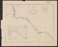
"A note upon the construction of this map with a list of documents made use of will be found in the, "Geographical Journal 1910.", Includes inset reliability diagram. Scale 1:10,000,000., Inset map showing same area at 1:10,000,000., and Relief shown by shading.
Publisher:
Royal Geographical Society,
Subject (Geographic):
Bolivia--Maps and Peru--Maps
Subject (Name):
Bingham, Hiram,--1831-1908.--Ownership and Royal Geographical Society (Great Britain)
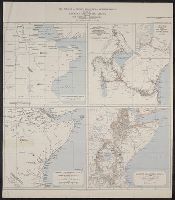
Maps of Eastern Equatorial Africa showing the progress of exploration
Description:
"Eastern Equatorial Africa, Garstin. The Geographical Journal, 1909"--in upper right hand corner. and Eastern Equatorial Africa according to Ptolemy, A.D. 150 -- Eastern Equatorial Africa immediately before Speke's first journey ... 1856 -- Map showing the results of Burton, Speke, and Grant's explorations ... 1863 -- Eastern Equatorial Africa, 1909.
Publisher:
Royal Geographical Society,
Subject (Geographic):
Africa, East--Discovery and exploration--Maps
Subject (Name):
Royal Geographical Society (Great Britain) and Speke, John Hanning,--1827-1864--Travel--Maps
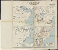
Maps of Eastern Equatorial Africa showing the progress of exploration
Description:
"Eastern Equatorial Africa, Garstin. The Geographical Journal, 1909"--in upper right hand corner. and Eastern Equatorial Africa according to Ptolemy, A.D. 150 -- Eastern Equatorial Africa immediately before Speke's first journey ... 1856 -- Map showing the re
Publisher:
Royal Geographical Society,
Subject (Geographic):
Africa, East--Discovery and exploration--Maps
Subject (Name):
Royal Geographical Society (Great Britain) and Speke, John Hanning,--1827-1864--Travel--Maps