Search
You Searched For
Search Results
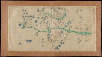
- Published / Created:
- [not after 1624]
- Call Number:
- Lanman 5626 1624
- Image Count:
- 1
- Resource Type:
- cartographic image
- Found in:
- Beinecke Rare Book and Manuscript Library > [Jiangxi Yuanzhou Fu tu]., [江西袁州府圖].
- Published / Created:
- [between 1910 and 1920]
- Call Number:
- BrSides Zc72 910cu
- Image Count:
- 2
- Resource Type:
- cartographic image
- Found in:
- Beinecke Rare Book and Manuscript Library > Cragmont
- Published / Created:
- [approximately 1960]
- Call Number:
- Art Storage 1019
- Image Count:
- 2
- Resource Type:
- cartographic image
- Found in:
- Beinecke Rare Book and Manuscript Library > [Portolan chart of the Mediterranean Sea, the North Atlantic Ocean, the Black Sea, and the northwestern African coast].
- Published / Created:
- [between 1800 and 1899?]
- Call Number:
- GEN MSS FILE 601 (Oversize)
- Image Count:
- 2
- Resource Type:
- cartographic image
- Found in:
- Beinecke Rare Book and Manuscript Library > Portolan chart of western Europe and the Mediterranean Sea
- Creator:
- Koyano, Ishun, creator
- Published / Created:
- Bunka 6, 6th month :
- Call Number:
- 2018 +512
- Image Count:
- 154
- Resource Type:
- cartographic image
- Found in:
- Beinecke Rare Book and Manuscript Library > Visualized map of all the countries
- Creator:
- United States. War Department. Corps of Engineers, cartographer, publisher
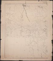
- Published / Created:
- [1881]
- Call Number:
- 831 1881A
- Image Count:
- 2
- Resource Type:
- cartographic image
- Found in:
- Beinecke Rare Book and Manuscript Library > Montana Territory
- Creator:
- Mitchell, Donald Grant, 1822-1908, cartographer
- Published / Created:
- Decr. 1863.
- Call Number:
- Roll Map 78
- Image Count:
- 2
- Resource Type:
- cartographic image
- Found in:
- Beinecke Rare Book and Manuscript Library > Map of a portion of Westville & New Haven
- Creator:
- Lehman, Christian, creator
- Published / Created:
- [1857]
- Call Number:
- 2018 Folio 173
- Image Count:
- 93
- Resource Type:
- cartographic image
- Found in:
- Beinecke Rare Book and Manuscript Library > An explanation of the original location and general plan or draught of the lands and lots of Germantown and Creesam Townships, copied from Matthias Zimmerman's original dated June 26th A.D. 1746, and of the several districts and divisions thereof, part extracted from original and former draughts and part done and taken from actual mensuration drawn by Christian Lehman, July 28, 1776, recopied by his grandson Joseph Lehman, January 1, 1824, from which recopy this copy was taken, August 1857, for Peter E. Keyser
- Creator:
- United States. General Land Office
- Published / Created:
- [1908]
- Call Number:
- BrSides Zc35 908un
- Image Count:
- 2
- Resource Type:
- cartographic image
- Found in:
- Beinecke Rare Book and Manuscript Library > Sectionized map of Cheyenne River and Standing Rock Indian Reservation opened by act of May 29, 1908 [cartographic material]
- Creator:
- Scott, F. H., Major, cartographer
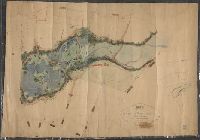
- Published / Created:
- 1855.
- Call Number:
- Covers 59 1855
- Image Count:
- 4
- Resource Type:
- cartographic image
- Found in:
- Beinecke Rare Book and Manuscript Library > Map of the peninsula of India, comprising the whole of the Madras Presidency, and portions of the adjacent territories of Bengal and Bombay [cartographic material]