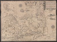
Exacta et accurata delineatis cum orarum maritimarum tum etjam locorum terrestrium and Waarachtige wtworpinghe ofte afbeeldinge van alle dje custen end landen
Description:
Appears in the author's Itinerario. 1596., Backed with paper., Has watermark., Includes ill., Latin and Dutch., Oriented with north to the left., and Relief shown pictorially.
Publisher:
C. Claesz,
Subject (Geographic):
Southeast Asia--Maps--Early works to 1800
Subject (Name):
Langren, Arnold Florent van, 1580-1644, Langren, Henricus F. ab (Henricus Florentius), ca. 1574-1648, engraver, Linschoten, Jan Huygen van, 1563-1611, and Linschoten, Jan Huygen van, 1563-1611. Itinerario, voyage ofte schipvae
Subject (Topic):
Nautical charts--South China Sea--Early works to 1800 and Nautical charts--Southeast Asia--Early works to 1800
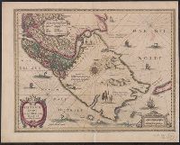
Bat. cum Privil. Ordin. Gener, Belgii Faederati--Title cartouche., Features include ornate title cartouche (top left) with cherubs, male and female figures and royal coat-of-arms supported by lion and unicorn, arms of Scotland supported by cherubs (above scale cartouche at top right), compass indicator and coasts shaded outwards., In Latin with some place names in English; explanations and title for index to places in Dutch and English., No. 7 of 69 maps bound together in composite atlas., Relief shown pictorially., Scale [ca. 1:960 000]., Scale statement reads: Milliaria Germanica Communia 15 in uno Gradu, with scale bar graded [0]-10; Milliaria Scotica Communia quorum 50 in uno Gradu, with scale bar graded [0]-34; Milliaria Gallica quae et Horae Itineris 20 in uno Gradu, with scale bar graded [0]-14., Shows grid, rivers and tributaries, lochs (shaded), trees, place and county names, settlements (symbols classified by importance in legend), territorial boundaries., Shows Scotland including the Hebrides and Orkney Islands., and The four cardinal points are written in the borders.
Cross Collection no. 350., From Jodocus Hondius's Appendix Atlantis majoris. [Amsterdam] : Per Iodocum Hondium, 1630., Imperfect: mutilated along fold at bottom, with no loss of text. Mounted on linen., Map of the Straits of Magellan, South America., Relief shown pictorially., and Title in Latin; place names in Dutch.
Publisher:
Judocus Hondius excudit,
Subject (Geographic):
Magellan, Strait of (Chile and Argentina)--Maps--Early works to 1800
Subject (Name):
Gryp, Dirck, engraver and Hondius, Jodocus, 1594 or 1595-1629. Appendix Atlantis majoris
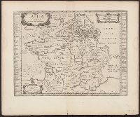
Atlas novus. and Gallia vetus ad Julij Caesaris commentaria
Description:
Latin text on recto; Dutch text on verso., Lower left corner: "Amstelodami apud Ioannem Ianβonium.", Published in Dutch editions of Jansson's Atlas novus (Dutch title: Nieuwen atlas, ofte vveerelts-beschrijvinge), vol. 6, ca. 1662, and Relief shown pictorially.
Publisher:
Jan Jansson,
Subject (Geographic):
France--History--To 987--Maps--Early works to 1800 and Gaul--Maps--Early works to 1800
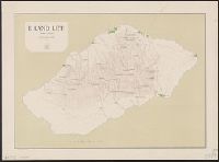
Jaarboek van het mijnwezen in Nederlandsch Oost-Indië.
Description:
Coordinates not present on map and are approximated., Relief shown by contour lines., and Removed from: Jaarboek van het Mijnwezen in Nederlandsch Oost-Indië (1872).