Bar scales given in "mill. Germanica," "mill. Gallica," and "mill. Italica.", Imperfect: torn along bottom fold, with no loss of text. Watermark. Manuscript number in right corner. From the Karpinski-von Wieser Map Collection., Includes illustration "Die Vestung Kofel.", Relief shown pictorially., and With privilege statement, "Cum privilegio Sac. Cas. Maj." at bottom of cartouche.
Bar scales given in "mill. Germanica," "mill. Gallica," and "mill. Italica.", Includes illustration "Die Vestung Kofel.", Ms. no. on verso: LII. Sheet measures 53 x 65.4 cm., and Relief shown pictorially.
Homann, Johann Baptist, 1663-1724 Visscher, Nicolaes, 1649-1702
Published / Created:
1715?]
Call Number:
327 1696
Container / Volume:
BRBL_00072
Image Count:
1
Resource Type:
Maps, Atlases & Globes
Description:
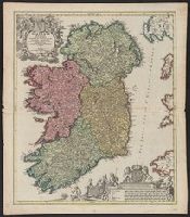
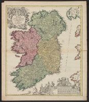
Bar scales include "milliaria germanica", "milliaria gallica", "milliaria anglica", "milliaria hibernica"., Copy 1: Sheet measures 62.1 x 53.6 cm., Latin and Engli, Relief shown pictorially., and With privilege statement, "Cum privilegio Sac. Caes. Maj."
Homann, Johann Baptist, 1663-1724 Visscher, Nicolaes, 1649-1702
Published / Created:
1715?]
Call Number:
327 1696
Container / Volume:
BRBL_00072
Image Count:
1
Resource Type:
Maps, Atlases & Globes
Description:
Bar scales include "milliaria germanica", "milliaria gallica", "milliaria anglica", "milliaria hibernica"., Copy 2: Sheet measures 61.6 x 54 cm. Ms. nos. on verso: 19; 80., Latin and English., Relief shown pictorially., and With privilege statement, "Cum privileg
Minimal level cataloging record. and Relief shown pictorially.
Publisher:
Homann,
Subject (Geographic):
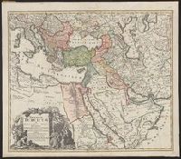
Middle East--Maps--Early works to 1800, Turkey--Administrative and political divisions--Maps--Early works to 1800, and Turkey--Maps--Early works to 1800
Tabula ex novissimus ad mentem de L'Islii, inprimis vero celeberrimi geographi Dni. I.M. Hasii, Prof. Vitemb. delineata a. 1737
Description:
"Cum privil. S.C.M. Grat.", Bar scales given in "milliaria Germanica," "milliaria Turcica," and "mill. Italica.", Relief shown pictorially., and Variant: without privilege statement in cartouche. Sheet measures 52.5 x 60.4 cm.
Publisher:
[Homann Erben,
Subject (Geographic):
Balkan Peninsula--Maps--Early works to 1800, Egypt--Maps--Early works to 1800, Libya--Maps--Early works to 1800, and Middle East--Maps--Early works to 1800
Subject (Name):
Hase, Johann Matthias, 1684-1742 and Homann Erben (Firm)
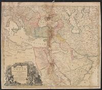
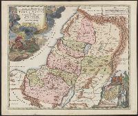
Has watermark., Inset: Populi Isräelitici ex Aegÿpto ... [shows route of the Exodus; Moses and Aaron standing nearby]., Map of Palestine divided among the 12 Tribes, drawn by Homann after Guillaume Sanson. The shoreline runs from Sidon to Rinocorura., and Reli
Publisher:
[Homann,
Subject (Geographic):
Palestine--History--To 70 A.D.--Maps--Early works to 1800 and Palestine--Maps--Early works to 1800
Subject (Name):
Sanson, Guillaume
Subject (Topic):
Bible.--O.T.--Geography--Maps--Early works to 1800
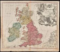
"Cum privilegio S.C.M.", Appeared in Homann's Atlas Novus Terrarum., Prime meridian: Ferro., Relief shown pictorially., Variant with portrait of George I in armour in the cartouche, Plymouth, England spelled correctly, and Delft, Netherlands misspelled "Dolft.", and Watermark. Manuscript number in upper right corner. From the Karpinski-von Wieser Map Collection.
Publisher:
[Johann Baptist Homann]
Subject (Geographic):
British Isles--Maps--Early works to 1800. and Europe--British Isles
Subject (Name):
Homann Erben (Firm) and Homann, Johann Baptist, 1663-1724. Atlas novus terrarum