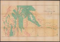
Geological and Geographical Survey of the Territories (U.S.)
Published / Created:
[1879]
Call Number:
833g 1879
Container / Volume:
BRBL_00586
Image Count:
1
Resource Type:
Maps, Atlases & Globes
Description:
"April 1879.", Includes notes., Relief shown by spot heights., Shows forests, vegetation, rock and coal, and arable lands., and To accompany the Survey's 13th (?) annual report.
Publisher:
Julius Bien, Lith., and The Survey ;
Subject (Name):
Hayden, F. V. (Ferdinand Vandeveer), 1829-1887
Subject (Topic):
Land capability for agriculture--Idaho--Maps, Land capability for agriculture--Utah--Maps, Land capability for agriculture--Wyoming--Maps, Natural resources--Idaho--Maps, and Natural resources--Utah--Maps
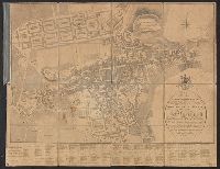
Map on p. 77: Winnipeg [scale 1:32,000]., Shows streets, railways, electric railway, city limits, churches and other major buildings., and Two atlas pages joined (p. 77 and 78); "Atlas of Canada" above top corners of each plate.
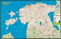
"LR MP G̦eodēzijas un kartogrāfijas departaments 1993. gada 6. janvārī atl̦āvis tiražēt un izplatīt.", Indexed., Panel title., and Title at upper left: Eesti 1:600 000.