All volumes bound to match 1973 Folio 72. Factitious collection of about 549 maps taken from the atlases of the 17th and the beginning of the 18th cent., put together with the title "Atlas" and bound in 6 volumes. These volumes originally bore the imprint: Amstelaedamii apvd Reiniervm & Josvam Ottens. Over these words on the title-pages of v. 1-2, 4-6 is the name of Henrik de Leth who painted them. Volume 3 has only the erased imprint of Ottens., For fuller description see Phillips 3448 and C. Koeman's Atlantes Neerlandici, bibliography of terrestrial, maritime and celestial atlases and pilot books, published in the Netherlands up to 1800, Amsterdam c1967-71, v. 2, p. 63-83., and Maps by P. Schenck and son, G. Valck, F. de Wit, N. Visscher and others.
Publisher:
chez J. Covens & C. Mortier,
Subject (Geographic):
Denmark --Maps --Early works to 1800
Subject (Name):
Reiner et Josua Ottens (Firm), Schenk, Peter, 1660-1718 or 1719., and Valck, G. (Gerard), 1651 or 1652-1726.
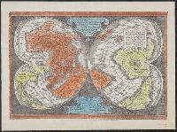
"Ne que ad nos Fram orbis ... Cappadocie 7.", "Quam hic vides orbis imagine lector cadide ... Vale 1538", Cordiform map of the world, 1538, Joanni Drosio suo Gerardus Rupelmudan deducabat., Map of the world, 1538, Orbis imago., and World map on double cordiform pro
Description:
Also known as World map on double cordiform projection and Orbis imago., Cross collection no. 4., Facsimile of Gerhard Mercator's first world map, published in Louvain, 1538., Relief shown pictorially., and Title from another facsimile published by the New York Public Library.
Publisher:
Julius Bien & Co., photo-lith,
Subject (Name):
Brevoort, James Carson, 1818-1887 and Julius Bien & Co
Subject (Topic):
Early maps--Facsimiles and World maps--Early works to 1800--Facsimiles