Skip to search
Skip to main content
Skip to first result
Search
You Searched For
Genre
Maps
Resource Type
Maps, Atlases & Globes
Language
Russian
New Search
Search Results
Creator:
Published / Created:
[1930]
Call Number:
35 1930
Container / Volume:
BRBL_00101
Image Count:
1
Resource Type:
Maps, Atlases & Globes
Alternative Title:
Союз Советских Социалистических Республик.
Description:
"Administrativnoe delenie na 10 i︠a︡nvari︠a︡ 1930 g.", "Glavlit. No. A-60639.", "Административное деление на 10 января 1930 г.", and "Главлит. No. А-60639."
Publisher:
Izdanie Kartoizdatelʹstva NKVD RSFSR, and Издание Картоиздательства НКВД РСФСР,
Subject (Geographic):
Soviet Union--Administrative and political divisions--Maps and Soviet Union--Maps.--Ms. notes
Found in:
Beinecke Rare Book and Manuscript Library > Soi︠u︡z Sovetskikh Sot︠s︡ialisticheskikh Respublik.
Creator:
Published / Created:
1884
Call Number:
352 Sa25 1884
Container / Volume:
BRBL_00108
Image Count:
1
Resource Type:
Maps, Atlases & Globes
Alternative Title:
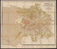
Справочный планъ С. Петербурга / составленъ по новейшимъ сведениямъ M. Мусницкимъ.
Description:
Depths shown by contours. and Shows street numbering.
Publisher:
A. Beggrova, and А. беггрова,
Subject (Geographic):
Saint Petersburg (Russia)--Maps
Subject (Topic):
Street addresses--Russia (Federation)--Saint Petersburg--Maps and Streets--Russia (Federation)--Saint Petersburg--Maps
Found in:
Beinecke Rare Book and Manuscript Library > Spravochnyĭ plan S. Peterburga / sostavlen po novi︠e︡ĭshim svi︠e︡di︠e︡nīi︠a︡m M. Musnit︠s︡kim.
Creator:
Published / Created:
[1962]
Call Number:
35j 1914
Container / Volume:
BRBL_00103
Image Count:
4
Resource Type:
Maps, Atlases & Globes
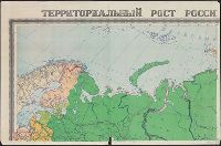
Alternative Title:
Территориальный рост Российской империи с 1700 по 1914 г. / составлено Научно-редакционной картосоставительской частью ГУГК ; ответственный редактор--Кучборская Е.П. ; технический редактор--Буханова Н.И.
Description:
"A-02908"., "Z-68.", "З-68.", Inset: Ali︠a︡ska. Scale 1:10,000,000., Inset: Аляска. Scale 1:10,000,000., and Relief shown by shading.
Publisher:
Glavnoe upravlenie geodezii i kartografii Gosudarstvennogo geologicheskogo komiteta SSSR, and Главное управление геодезии и картографии Государственного геологического комитета СССР,
Subject (Geographic):
Russia--History--Maps and Soviet Union--Territorial expansion--Maps
Subject (Name):
Kuchborskai︠a︡, E. P and Кучборская, Е. П
Found in:
Beinecke Rare Book and Manuscript Library > Territorialʹnyĭ rost Rossiĭskoĭ imperii s 1700 po 1914 g. / sostavleno Nauchno-redakt︠s︡ionnoĭ kartosostavitelʹskoĭ chastʹi︠u︡ GUGK ; otvetstvennyĭ redaktor--Kuchborskai︠a︡ E.P. ; tekhnicheskiĭ redaktor--Bukhanova N.I.
Creator:
Call Number:
547 1892A
Container / Volume:
BRBL_00291
Image Count:
3
Resource Type:
Maps, Atlases & Globes
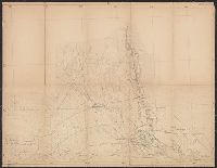
Alternative Title:
Zakaspiiskoĭ Oblasti, Закаспийской Области, and Закаспійской Области.
Description:
E.7. -- E.8. -- F.7., Imperfect: some sheet chipped at edges, with some loss of text; some sheets wanting. Dissected and mounted on linen., and Relief shown by shading.
Subject (Geographic):
Turkmenistan--Maps
Found in:
Beinecke Rare Book and Manuscript Library > Zakaspīiskoĭ Oblasti.
Published / Created:
[1870]
Call Number:
30ed 1870
Container / Volume:
BRBL_00037B
Image Count:
1
Resource Type:
Maps, Atlases & Globes
Description:
In Russian.
Subject (Geographic):
Europe--Maps
Found in:
Beinecke Rare Book and Manuscript Library > [Europe Ethnographic].
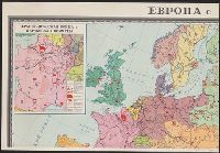
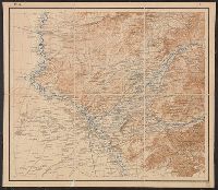
Published / Created:
[19--]
Call Number:
30f 1914
Container / Volume:
BRBL_00037B
Image Count:
4
Resource Type:
Maps, Atlases & Globes
Description:
Insets: Moscow ca. 1:50,000.
Subject (Geographic):
Europe--Maps
Found in:
Beinecke Rare Book and Manuscript Library > [Europe in 1870-1914].
Creator:
Call Number:
547 1897
Container / Volume:
BRBL_00291
Image Count:
6
Resource Type:
Maps, Atlases & Globes
Alternative Title:
[Карта десятиверстная Туркестанского Военного Округа].
Description:
"Pod redakt︠s︡īeĭ polkovn. Rodīonova.", "Sostav. klas. topogr. Khondazhevskīĭ, graviroval [?], 1897 g."--Sheet P. VII, L.8., "Под редакціей полков. Родіонова.", "Состав. клас. топогр. Хондажевскій, гравировалъ [?], 1897 г."--Sheet P. VII, L.8., and Imperfect
Subject (Geographic):
Asia, Central--Maps
Found in:
Beinecke Rare Book and Manuscript Library > [Karta desi︠a︡tiverstnai︠a︡ Turkestanskogo Voennogo Okruga].
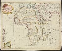
Published / Created:
1722
Call Number:
60 1722
Container / Volume:
BRBL_00323
Image Count:
1
Resource Type:
Maps, Atlases & Globes
Description:
Resembles Guillaume de L'Isle's map of Africa, except there is less interior detail in the Russian map ...
Subject (Geographic):
Africa--Maps--Early works to 1800
Found in:
Beinecke Rare Book and Manuscript Library > [Map of Africa].
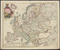
Published / Created:
[1720?]
Call Number:
30 1720
Container / Volume:
BRBL_00029
Image Count:
1
Resource Type:
Maps, Atlases & Globes
Description:
Preliminary record. and Text in Russian, ca. 1720.
Subject (Geographic):
Europe--Maps--Early works to 1800
Found in:
Beinecke Rare Book and Manuscript Library > [Map of Europe, completely identical to the maps of Guillaume de L'Isle].
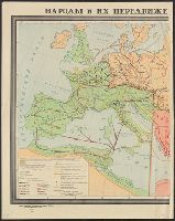
Published / Created:
[19--].
Call Number:
30em 350-650
Container / Volume:
BRBL_00037B
Image Count:
2
Resource Type:
Maps, Atlases & Globes
Description:
In Russian.
Subject (Geographic):
Europe--Maps
Found in:
Beinecke Rare Book and Manuscript Library > [Migrations of peoples in Europe during the 4th-7th centuries].
Branch:v1.64.3 ,Deployed:2024-09-25T10:53:04-04:00