Search
You Searched For
Search Results
- Call Number:
- 1977 +379
- Collection Title:
- Geografia; cioè, Descrittione vniversale della terra. Partita in due volumi, nel primo de' quali si
- Image Count:
- 1
- Resource Type:
- Maps, Atlases & Globes
- Alternative Title:
- Descrittione di tvtto'l mondo, secondo la prattica de Marinari. Vniversi orbis descriptio ad vsvm navigantivm.
- Subject (Topic):
- Geography
- Collection Created:
- In Padova, Appresso Paolo, & Francesco Galignani, fratelli, 1620-21 [v.1, 1621]
- Found in:
- Beinecke Rare Book and Manuscript Library > [Geographia. Italian]
- Call Number:
- 1977 +435
- Collection Title:
- Geografia; cioè, Descrittione vniversale della terra. Partita in due volumi, nel primo de' quali si
- Image Count:
- 1
- Resource Type:
- Maps, Atlases & Globes
- Alternative Title:
- Descrittione dell'America, odell'India Occidentale. America.
- Subject (Topic):
- Geography, Ancient
- Collection Created:
- In Venetia, Appresso Gio. Battista & Giorgio Galignani, fratelli, 1597-8 [v.1 1598]
- Found in:
- Beinecke Rare Book and Manuscript Library > [Geographia. Italian]
- Call Number:
- 1977 +435
- Collection Title:
- Geografia; cioè, Descrittione vniversale della terra. Partita in due volumi, nel primo de' quali si
- Image Count:
- 1
- Resource Type:
- Maps, Atlases & Globes
- Alternative Title:
- Descrittione di tvtto'l mondo, secondo la prattica de Marinari. Vniversi orbis descriptio ad vsvm navigantivm.
- Subject (Topic):
- Geography, Ancient
- Collection Created:
- In Venetia, Appresso Gio. Battista & Giorgio Galignani, fratelli, 1597-8 [v.1 1598]
- Found in:
- Beinecke Rare Book and Manuscript Library > [Geographia. Italian]
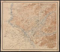
- Creator:
- Russia. Turkestanskiĭ Voennyĭ Okrug Voenno Topograficheskiĭ Otdel
Россия. Туркестанский Военный Округ Военно Топографический Отдел
- Call Number:
- 547 1897
- Container / Volume:
- BRBL_00291
- Image Count:
- 6
- Resource Type:
- Maps, Atlases & Globes
- Alternative Title:
- [Карта десятиверстная Туркестанского Военного Округа].
- Description:
- "Pod redakt︠s︡īeĭ polkovn. Rodīonova.", "Sostav. klas. topogr. Khondazhevskīĭ, graviroval [?], 1897 g."--Sheet P. VII, L.8., "Под редакціей полков. Родіонова.", "Состав. клас. топогр. Хондажевскій, гравировалъ [?], 1897 г."--Sheet P. VII, L.8., and Imperfect
- Subject (Geographic):
- Asia, Central--Maps
- Found in:
- Beinecke Rare Book and Manuscript Library > [Karta desi︠a︡tiverstnai︠a︡ Turkestanskogo Voennogo Okruga].
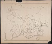
- Call Number:
- 771hc B796 1776A
- Container / Volume:
- BRBL_00495
- Image Count:
- 1
- Resource Type:
- Maps, Atlases & Globes
- Subject (Geographic):
- Brooklyn (New York, N.Y.)--Maps--Early works to 1800
- Found in:
- Beinecke Rare Book and Manuscript Library > [Map of Brooklyn, N.Y., showing the battle in this area in 1776, superimposed upon a modern street map.]
- Call Number:
- 1971 Folio 602
- Collection Title:
- Carte topographique de lEgypte et de plusiers parties des pays limitrophes; levee pendant
- Image Count:
- 1
- Resource Type:
- Maps, Atlases & Globes
- Alternative Title:
- Description de lEgypte
- Subject (Geographic):
- Egypt., Israel, Middle East., and Red Sea.
- Collection Created:
- Paris
- Found in:
- Beinecke Rare Book and Manuscript Library > [Map of Egypt, the Red Sea, Palestine, the Sinai Peninsula and other Middle Eastern landmarks]. pl. 2.
- Call Number:
- 11ba 1915
- Container / Volume:
- BRBL_00010A
- Image Count:
- 1
- Resource Type:
- Maps, Atlases & Globes
- Description:
- Sectional globe, showing steamship routes and transcontinental railways.
- Publisher:
- London Geographical Institute
- Subject (Geographic):
- World--maps
- Found in:
- Beinecke Rare Book and Manuscript Library > [Philips' 12 inch terrestrial globe.]
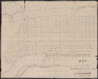
- Call Number:
- 771 OS9 1836
- Container / Volume:
- BRBL_00490
- Image Count:
- 1
- Resource Type:
- Maps, Atlases & Globes
- Description:
- Inset: The vicinity of Oswego Falls and Preliminary record.
- Publisher:
- P.A. Messier's, Lith.
- Subject (Geographic):
- Oswego County (N.Y.)--Maps
- Found in:
- Beinecke Rare Book and Manuscript Library > map of the Village of Oswego Falls to be Sold on hte Premises by Jas. Bleecker & Sons on the 18th October 1836.
- Call Number:
- 783 1673D
- Container / Volume:
- BRBL_00507
- Image Count:
- 1
- Resource Type:
- Maps, Atlases & Globes
- Description:
- Facsimile.
- Subject (Geographic):
- Virginia--Maps--Early works to 1800
- Found in:
- Beinecke Rare Book and Manuscript Library > virginia and Maryland. As it is planted and inhabited this present year 1670. Surveyed and Exactly Drawne by ... Augustin Herrman, 1673.