Bankoku ichiranzu, Bankoku ichiran zusetsu, and (Explanation of the visualized map of all the countries)
Description:
BEIN 2018 +512: Manuscript annotations in English on margins of map., Cover attached; cover and map title the same., Accompanied by: BANKOKU ICHIRAN ZUSETSU : (Explanation of the visualized map of all the countries) / Koyano Yoshiharu. -- Bunka 7 : (1810). -- 2 v., ill. ; 25.2 x 18 cm., Kôzanrō is a private school of Koyano Yoshiharu., and California shown as an island.
Publisher:
Kôzanrô, (June, 1809)
Subject (Geographic):
Japan and Japan.
Subject (Topic):
World maps, Geography, Study and teaching, and Prints, Japanese
Gastaldi, Giacomo, approximately 1500-approximately 1565
Published / Created:
[1897]
Call Number:
11 1546
Image Count:
1
Resource Type:
Maps, Atlases & Globes
Alternative Title:
Remarkable maps of the XVth, XVIth and XVIIth centuries ; pt. 4, no. 8., Reproductions of geographical maps ; [pt. 4, no. 8], and Universale
Description:
Facsimile., Relief shown pictorially., Series title commonly cited as Remarkable maps of the XVth, XVIth and XVIIth centuries., and World map on an oval projection.
Publisher:
Frederik Muller,
Subject (Topic):
Early maps, Early maps--Facsimiles, World maps, and World maps--Early works to 1800--Facsimiles
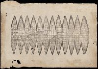
A photomechanical print probably created during the early twentieth century as a forgery that reproduces twelve gores for a globe published in 1507 by Martin Waldseemüller based on his wall map, Universalis Cosmographia (1507). and Evidence of the forgery includes the superimposition of the gores over glue already on the paper surface, which suggests use of a sheet removed from a period volume, as well as details that replicate gores from an authentic woodcut print formerly owned by Austrian cartographer Franz Hauslab and acquired by the James Ford Bell Library at the University of Minnesota in 1954
Description:
A gore is a roughly triangular or wedge-shaped segment of an object, as found in domes and globes, where a sector of a curved surface, or a curved surface that lies between two close lines of longitude on a globe, and flattened to a plane surface with little distortion., Martin Waldseemüller (1470-1519) was a German cartographer. His wall map Universalis Cosmographia (1507) and printed globes contemporarily derived from it were the first published globular maps of the Western Hemisphere and the first maps on which the name America appears in honor of Italian explorer Amerigo Vespucci (1454-1512)., In Latin., Title devised by cataloger., and Publication place and date of creation supplied by the cataloger.
Subject (Geographic):
America
Subject (Name):
Hauslab, Franz, 1798-1883., Vespucci, Amerigo, 1451-1512., and Waldseemüller, Martin, 1470-1519
Subject (Topic):
Forgeries, Globes, World maps, Discovery and exploration, and Name
"Photolithographed copy of Gerard Mercator's Mapamundi of 1538 from an original engraving in the library of the American Geographical Society.", Relief shown pictorially., and Title devised by cataloger.
Publisher:
Julius Bien & Co., photo-lith,
Subject (Geographic):
World--Maps--Early works to 1800
Subject (Name):
American Geographical Society of New York and Julius Bien & Co
Subject (Topic):
Early maps, Early maps--Facsimiles, World maps, and World maps--Early works to 1800