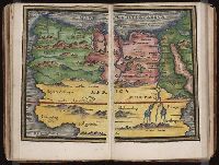
New England: the most remarqueable parts thus named by the high and mighty Prince Charles, nowe King of great Britaine [map] and Path-way to experience to erect a plantation.
Description:
Imperfect: damp-stained; added port. of Charles I., Map with portrait of Capt. Smith in corner: New England ... / observed and described by Captayn John Smith. 1614. Pendleton's Lithography, Boston. Drawn by J. Eddy. London, printed by Geor: Low., Signatures: A-F⁴., and Teaching resource: Professor John Mack Faragher, History 141: The American West.
Publisher:
Printed by I. Haviland, and are to be sold by R. Milbovrne,
Subject (Geographic):
Massachusetts--History--Colonial period, ca. 1600-1775, Massachusetts--Maps--Early works to 1800, New England--Description and travel, New England--History--Colonial period, ca. 1600-1775, and New England--Maps--Early works to 1800
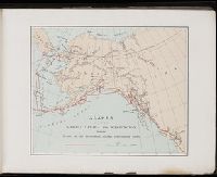
A souvenir of the Harriman Alaska Expedition : May-August, 1899 [graphic]
Image Count:
1
Resource Type:
Maps, Atlases & Globes
Abstract:
Edward Henry Harriman organized and funded a scientific expedition up the Alaska coast that included George Bird Grinnell, Grove Karl Gilbert, John Muir, Frederick Dellenbaugh, C. Hart Merriam, and other scientists, artists and writers, as well as his own
Subject (Geographic):
Alaska--Description and travel
Subject (Name):
Harriman Alaska Expedition (1899)--Pictorial works