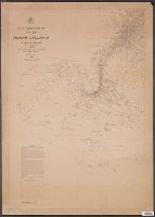
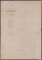
[Maury map collection ; Series D1], Maury's wind & current chart : thermal sheet., North Atlantic, and Thermal sheet
Description:
Copy imperfect: Sheet torn and repaired along fold-line and edges. Discoloration throughout., Each sheet numbered in upper left margin, e.g.: 14, 15., and Sheet 1 (1850), 3 copies -- Sheet 1 (1852) -- Sheet 2, 2 copies -- Sheet 3, 3 copies -- Sheet 4, 3 copies
Publisher:
United States Hydrographical Office,
Subject (Geographic):
North Atlantic Ocean--Maps
Subject (Name):
Gantt, Benjamin S., -1852, Maury, Matthew Fontaine, 1806-1873. Wind and current charts, United States Naval Observatory, United States. Bureau of Ordnance and Hydrography, United States. Hydrographic Office, and Warrington, L. (Lewis), 1782-1851
Subject (Topic):
Nautical charts--North Atlantic Ocean and Ocean temperature--North Atlantic Ocean--Maps
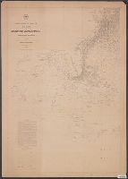
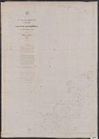
[Maury map collection ; Series D1], Maury's wind & current chart : thermal sheet., North Atlantic, and Thermal sheet
Description:
DLC, Each sheet numbered in upper left margin, e.g.: 14, 15., Includes notes in map area and signature of M.F. Maury., Shows temperature of the water at the surface by month., and Thermal charts were released as series D a part of Maury's "Wind and current charts
Publisher:
United States Hydrographical Office,
Subject (Geographic):
North Atlantic Ocean--Maps
Subject (Name):
Gantt, Benjamin S., -1852, Maury, Matthew Fontaine, 1806-1873. Wind and current charts, United States Naval Observatory, United States. Bureau of Ordnance and Hydrography, United States. Hydrographic Office, and Warrington, L. (Lewis), 1782-1851
Subject (Topic):
Nautical charts--North Atlantic Ocean and Ocean temperature--North Atlantic Ocean--Maps
[Maury map collection ; Series A4], Maury's wind & current chart, North Pacific, Maury's wind and current chart, North Pacific, North Pacific, and Wind and current chart, North Pacific
Description:
"Lith. of J. Bien, 180 Broadway N.Y."--Sheets 6 and 10, lower right margin., "Series A.", Complete in 10, Copy imperfect: All sheets fold lined, with some tears along fold-line. Sheet 4 discoloration throughout, mounted on cloth backing., DLC, and Includes notes.
Publisher:
United States Hydrographical Office,
Subject (Geographic):
North Pacific Ocean--Charts, diagrams, etc
Subject (Name):
Bien, Julius, 1826-1909, Fillebrown, Thomas Scott, 1834-1884, Gibbon, Lardner, Johnson, A. W, Maury, Matthew Fontaine, 1806-1873. Wind and current charts, Porter, B. S, United States Naval Observatory, United States. Bureau of Ordnance and Hydrography, and United States. Hydrographic Office
[Maury map collection ; Series A4], Maury's wind & current chart, North Pacific, Maury's wind and current chart, North Pacific, North Pacific, and Wind and current chart, North Pacific
Description:
Sheet 1 (not issued) -- Sheet 2 (1851) -- Sheet 3 (1850) -- Sheet 4 (no date) -- Sheet 5 (1849) -- Sheet 6 (no date) -- Sheet 7 (no date) -- Sheet 8 (no date) -- Sheet 9 (no date) -- Sheet 10 (1852) -- Sheet 11 (1852). and Shows prevailing wind direction by m
Publisher:
United States Hydrographical Office,
Subject (Geographic):
North Pacific Ocean--Charts, diagrams, etc
Subject (Name):
Bien, Julius, 1826-1909, Fillebrown, Thomas Scott, 1834-1884, Gibbon, Lardner, Johnson, A. W, Maury, Matthew Fontaine, 1806-1873. Wind and current charts, Porter, B. S, United States Naval Observatory, United States. Bureau of Ordnance and Hydrography, and United States. Hydrographic Office
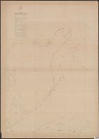
[Maury map collection ; Series D2], Maury's wind & current chart : South Atlantic, and South Atlantic
Description:
"Series D.", Copy imperfect: Sheets 1-4 torn and repaired along fold line, Does not cover the southeastern Atlantic south of latitude 40° S., and Originally intended to be complete in 6 sheets. Sheets 5 and 6, covering the southeastern Atlantic, were not issued.
Publisher:
United States Hydrographical Office,
Subject (Geographic):
South Atlantic Ocean--Maps
Subject (Name):
Maury, Matthew Fontaine, 1806-1873. Wind and current charts, Morris, Charles, 1784-1856, United States Naval Observatory, United States. Bureau of Ordnance and Hydrography, and United States. Hydrographic Office
Subject (Topic):
Nautical charts--South Atlantic Ocean and Ocean temperature--South Atlantic Ocean--Maps
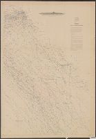
[Maury map collection ; Series D2], Maury's wind & current chart : South Atlantic, and South Atlantic
Description:
Copy imperfect: Sheets 1-4 torn and repaired along fold line., DLC, Does not cover the southeastern Atlantic south of latitude 40° S., Each sheet numbered in upper left margin, e.g.: 72, 73, 74, 75., Includes notes in map area and signature of M.F. Maury., and She
Publisher:
United States Hydrographical Office,
Subject (Geographic):
South Atlantic Ocean--Maps
Subject (Name):
Maury, Matthew Fontaine, 1806-1873. Wind and current charts, Morris, Charles, 1784-1856, United States Naval Observatory, United States. Bureau of Ordnance and Hydrography, and United States. Hydrographic Office
Subject (Topic):
Nautical charts--South Atlantic Ocean and Ocean temperature--South Atlantic Ocean--Maps
[Maury map collection ; Series D2], Maury's wind & current chart : South Atlantic, and South Atlantic
Description:
Copy imperfect: Sheets 1-4 torn and repaired along fold line., DLC, Does not cover the southeastern Atlantic south of latitude 40° S., Each sheet numbered in upper left margin, e.g.: 72, 73, 74, 75., Includes notes in map area and signature of M.F. Maury., and Ori
Publisher:
United States Hydrographical Office,
Subject (Geographic):
South Atlantic Ocean--Maps
Subject (Name):
Maury, Matthew Fontaine, 1806-1873. Wind and current charts, Morris, Charles, 1784-1856, United States Naval Observatory, United States. Bureau of Ordnance and Hydrography, and United States. Hydrographic Office
Subject (Topic):
Nautical charts--South Atlantic Ocean and Ocean temperature--South Atlantic Ocean--Maps
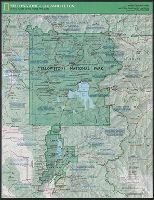
National Geographic Society (U.S.). Cartographic Division
Published / Created:
c1989.
Call Number:
833 Y38 1989
Container / Volume:
BRBL_00584
Image Count:
2
Resource Type:
Maps, Atlases & Globes
Alternative Title:
Special places of the world map series
Description:
"Supplement to the National Geographic, February 1989, page 216A, vol. 175, no.2-Yellowstone/Grand Teton.", Panel title., Relief shown by shading and spot heights., and Text, maps and col. ill. on verso.
Publisher:
The Society,
Subject (Geographic):
Grand Teton National Park (Wyo.)--Maps and Yellowstone National Park--Maps
"A.M.S. 5301.", Cloth map (silk)., For further information see a Web site devoted to the history and identification of the AAF cloth maps., Heights and depths in meters., Includes: Index to boundarie, and Relief shown by gradient tints, contours, and spot heights.
Publisher:
Amy Map Service,
Subject (Geographic):
East Asia--Maps
Subject (Name):
United States. Army Map Service
Subject (Topic):
Military geography--Japan--Kagoshima--Maps, Military geography--Japan--Nagasaki--Maps, Military maps, Military topography--Japan--Kagoshima--Maps, and Military topography--Japan--Nagasaki--Maps