"To accompany 'The Journals, detailed reports, & observations' presented to both Houses of Parliament, by command of Her Majesty, 19th May, 1863." and Facsim. reproduced by lithography by Robert MacLehose & Co. Ltd., the University Press, Glasgow, from the or
Publisher:
Robert MacLehose & Co., the University Press,
Subject (Geographic):
Northwest, Canadian--Discovery and exploration--Maps, Northwest, Canadian--Historical geography--Maps, and Northwest, Canadian--Maps
Subject (Name):
British North American Exploring Expedition (1857-1860), Edward Stanford Ltd, Hector, James, Sir, 1834-1907, and Robert MacLehose & Co
Pictorial border consisting of 5 inset maps: Melish's map, 1816, Penn's lots, 1698, Penn's plan, 1682, New Sweden, 1654, and the Sesqvi Centennial international exposition; the seals of Penn's colony and of the city of Philadelphia, 1701 and 1784; and 38 historical scenes.
Covers Brunei, Sabah, and northern Sarawak., Includes inset location map., Land available for sale or sold indicated., Library copy accompanied by manuscript notes., and Relief shown by hachures and spot heights. Soundings in fathoms.
Publisher:
Published by Edward Stanford for the British North Borneo Company,
National Geographic Society (U.S.). Cartographic Section
Published / Created:
1954
Call Number:
844 1954
Container / Volume:
BRBL_00603
Image Count:
1
Resource Type:
Maps, Atlases & Globes
Description:
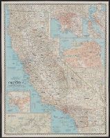
"Compiled by R.J. Darley, R.G. Fritz, A.D. Grazzini, R.E. McAleer, R.W. Northrop, W.T. Peele, F.W. Sheppard, and C.L. Stern. Physiography by J.J. Brehm and A.E. Holdstock. Typography by C.E. Riddiford." and Ancillary maps: Los Angeles [Scale 1:380,160] -- San Francisco Bay region [Scale 1:380,160] -- San Francisco [Scale ca. 1:41,000] -- San Diego [Scale 1:190,080] -- Yosemite Valley, Yosemite National Park [Scale 1:63,360].
Publisher:
National Geographic Society,
Subject (Geographic):
California--Maps
Subject (Name):
Brehm, J. J, Darley, Richard J, Fritz, R. G, Grazzini, Athos D, Holdstock, A. E, McAleer, Ralph E, Northrop, R. W, Peele, William T, Riddiford, Charles E, and S
National Geographic Society (U.S.). Cartographic Section
Published / Created:
1954
Call Number:
844 1954
Container / Volume:
BRBL_00603
Image Count:
1
Resource Type:
Maps, Atlases & Globes
Description:
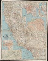
"Compiled by R.J. Darley, R.G. Fritz, A.D. Grazzini, R.E. McAleer, R.W. Northrop, W.T. Peele, F.W. Sheppard, and C.L. Stern. Physiography by J.J. Brehm and A.E. Holdstock. Typography by C.E. Riddiford." and Ancillary maps: Los Angeles [Scale 1:380,160] -- San Francisco Bay region [Scale 1:380,160] -- San Francisco [Scale ca. 1:41,000] -- San Diego [Scale 1:190,080] -- Yosemite Valley, Yosemite National Park [Scale 1:63,360].
Publisher:
National Geographic Society,
Subject (Geographic):
California--Maps
Subject (Name):
Brehm, J. J, Darley, Richard J, Fritz, R. G, Grazzini, Athos D, Holdstock, A. E, McAleer, Ralph E, Northrop, R. W, Peele, William T, Riddiford, Charles E, and S
Map of China showing the stations of the China Inland Mission
Description:
"China Inland Mission stations with resident missionary are underlined in red.", "Stanford's Geog! Estab., London.", and Covers on verso not digitized.