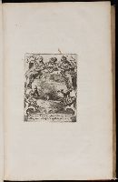
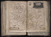
[Atlas factice of 96 maps by Blaeu, Visscher, Jansson, Hondius and others]
Image Count:
1
Description:
Imperfect: some ill. cut out or mutilated and replaced in ms.; torn along fold, with some loss of text. Sheet measures 41.3 x 57.5 cm. Reinforced along edges with printed waste. No. 87 of 92 maps bound together. and Numbered 93 on verso.
Blaeu, Willem Janszoon, 1571-1638 Lubin, Eilhard, 1565-1621 Rogiers, Salomon, engraver
Published / Created:
[ca. 1630]
Call Number:
1983 Folio 19
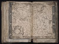
Collection Title:
[Atlas factice of 96 maps by Blaeu, Visscher, Jansson, Hondius and others]
Image Count:
1
Description:
Imperfect: slightly mutilated along fold, with no loss of text. Reinforced along edges with printed waste. Sheet measures 39.1 x 51.2 cm. No. 79 of 92 maps bound together. and Numbered 85 [81, cancelled] on verso.
Publisher:
Guiljelm. Blaeuw excudit
Subject (Geographic):
Pomerania (Poland and Germany) --Maps --Early works to 1800
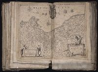
[Atlas factice of 96 maps by Blaeu, Visscher, Jansson, Hondius and others]
Image Count:
1
Description:
Imperfect: torn and repaired in lower right corner, with no loss of text. Sheet measures 39.5 x 50.2 cm. Reinforced along edges with paper. No. 53 of 92 maps bound together. and Numbered 57 on verso.
Publisher:
Everardus Cloppenburghius excudit
Subject (Geographic):
Bohemia (Czech Republic) --Maps --Early works to 1800
Appears in Wit's Atlas major., Includes coats of arms., No. 22 of 69 maps bound together in composite atlas., Relief shown pictorially., and Scale [ca. 1:1 100 000].
Publisher:
[Frederik de Wit]
Subject (Geographic):
Italy, Southern --Maps --Early works to 1800 and Naples (Kingdom) --Maps --Early works to 1800
[Atlas factice of 96 maps by Blaeu, Visscher, Jansson, Hondius and others]
Image Count:
1
Description:
Imperfect: cartouche cut out and replaced in ms. with title Silesia Dvcatvs; edges reinforced with ms waste. Hand col. Sheet measures 38.8 x 51 cm. No. 69 of 92 maps bound together. and Numbered 74 [and 71, cancelled] on verso.
Bar scales given in milliaria Germanica communia and milliaria Gallica communia., Ferro meridian., No. 54 of 69 maps bound together in composite atlas., Relief shown pictorially., and Scale [ca 1:1 330 000].
Mortier, David Mortier, Pierre Sanson, Nicolas, 1600-1667, creator
Published / Created:
[1710]
Call Number:
1973 Folio 10
Image Count:
1
Resource Type:
Maps, Atlases & Globes
Alternative Title:
Premiere carte de la Meuse avec les pais, duchez et comtez voisins and Teatre de la guerre en Flandre et Brabant
Description:
Alternate title in upper margin: Premiere carte de la Meuse avec les pais, duchez et comtez voisins., Does not show troop positions or other military locations., Ferro meridian., Imperfect: western sheet (with title cartouche) wanting. Part of eastern map (inset of Arras/Cambrai region) pasted over correction[?]., Includes inset of Arras/Cambrai region and color illustration of battles at upper left and lower right., No. 47 of 69 maps bound together in composite atlas., Originally printed on 4 sheets., Presentee a son altesse Monseigneur le Duc & Comte [sic] de Marlborough, Marquis de Blandford, &c. &c. &c., par son tres-humble et tres-obeissant serviteur, Pierre Mortier, libraire a Amsterdam., Relief shown pictorially., and Scale [ca. 1:250 000].
Publisher:
Apud Petrum Mortier, et se vend a Londres chez David Mortier
Subject (Topic):
Spanish Succession, War of, 1701-1714 --Maps --Early works to 1800
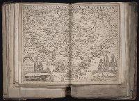
Blaeu, Willem Janszoon, 1571-1638. Atlantis appendix Emmius, Ubbo, 1547-1625
Published / Created:
[1630]
Call Number:
1983 Folio 19
Collection Title:
[Atlas factice of 96 maps by Blaeu, Visscher, Jansson, Hondius and others]
Image Count:
1
Description:
Imperfect: mutilated along fold, with some loss of text. Reinforced along lower edges with manuscript waste. Sheet measures 39.2 x 51 cm. No. 58 of 92 maps bound together. and Numbered 62 on verso.
Publisher:
Guiljelm. Blaeuw excudit
Subject (Geographic):
Lower Saxony (Germany) --Maps --Early works to 1800