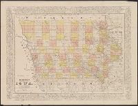
Colton, G. Woolworth (George Woolworth), 1827-1901
Published / Created:
1862
Call Number:
754gme 1860A
Container / Volume:
BRBL_00420
Image Count:
1
Resource Type:
Maps, Atlases & Globes
Alternative Title:
Colton's county and township railroad map of Wisconsin, Illinois, Missouri, & Iowa, County and township rail road map of Wisconsin, Illinois, Missouri, & Iowa, and Wisconsin, Illinois, Missouri, & Iowa
Description:
"Entered according to Act of Congress by Thayer & Colton in the Clerk's office of the District Court of the United States for the Southern District of New York in t and Does not include northern half of Wisconsin; Appleton is the northernmost town on the map.
Publisher:
Drawn, engraved & published by G. Woolworth Colton; and Rufus Blanchard,
Subject (Geographic):
Illinois--Maps, Iowa--Maps, Missouri--Maps, and Wisconsin--Maps
Subject (Name):
Blanchard, Rufus, 1821-1904
Subject (Topic):
Railroads--Illinois--Maps, Railroads--Iowa--Maps, Railroads--Missouri--Maps, and Railroads--Wisconsin--Maps
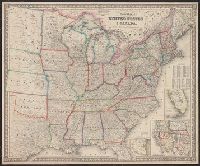
Colton, G. Woolworth (George Woolworth), 1827-1901
Published / Created:
1862, c1861.
Call Number:
75 1862C
Container / Volume:
BRBL_00403
Image Count:
1
Resource Type:
Maps, Atlases & Globes
Alternative Title:
Guide map of the United States & Canada. and New Guide map of the United States & Canada.
Description:
Insets: Plan of the southern portion of Florida.--Western portion of the United States., Prime meridians: Greenwich, Washington., Relief shown by hachures., and Table: Population of the United States.
"Entered according to act of Congress in the year 1856 by Charles W. Morse in the clerk's office of the district court of the United States for the southern district of New York." and Prime meridians: Greenwich and Washington.