Skip to search
Skip to main content
Skip to first result
Search
You Searched For
Repository
Beinecke Rare Book and Manuscript Library
Resource Type
Maps, Atlases & Globes
Language
Latin
Publication Place
Amsterdam :
New Search
Search Results
Creator:
Published / Created:
17--?]
Call Number:
70 1710
Container / Volume:
BRBL_00354
Image Count:
1
Resource Type:
Maps, Atlases & Globes
Alternative Title:
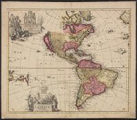
America Meridionalis accuratissima
Description:
Includes ill. of figures around each title. and Relief shown pictorially.
Publisher:
[P. Schenk?,
Subject (Geographic):
Western Hemisphere--Maps--Early works to 1800
Found in:
Beinecke Rare Book and Manuscript Library > America Septentrionalis novissima / P. Schenk ex: Amsteloed: cum privil.
Published / Created:
[1675]
Call Number:
331 Am88 1675
Container / Volume:
BRBL_00079
Image Count:
1
Resource Type:
Maps, Atlases & Globes
Publisher:
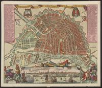
Gedruckt by Carel Allardt.,
Subject (Geographic):
Amsterdam (Netherlands)--Maps--Early works to 1800
Found in:
Beinecke Rare Book and Manuscript Library > Amstelodamum vetus et novissimum per Carolum Allardt.
Creator:
Published / Created:
[ca. 1700?]
Call Number:
41 AU79 1700
Container / Volume:
BRBL_00242
Image Count:
1
Resource Type:
Maps, Atlases & Globes
Publisher:
N. Visscher,
Subject (Geographic):
Austria--Maps--Early works to 1800
Subject (Name):
Albany Institute Stamp and Gouwen, Gilliam van der, engraver
Found in:
Beinecke Rare Book and Manuscript Library > Austriae archiducatus pars superior in omnes ejusdem quadrantes ditiones accuratissime et distincte delineata [cartographic material] / per Nic. Visscher.
Creator:
Published / Created:
[1690?]
Call Number:
335 1690
Container / Volume:
BRBL_00085
Image Count:
1
Resource Type:
Maps, Atlases & Globes
Description:
Map digitized.
Publisher:
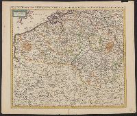
Frederick de Wit inde Kalverstraet inde Witte Pascaert,
Subject (Geographic):
Belgium--Maps--Early works to 1800
Found in:
Beinecke Rare Book and Manuscript Library > Belgii regii accuratissima tabula pluribus locis / recens emen: A F. De Wit.
Published / Created:
1712
Call Number:
3366 1712
Container / Volume:
BRBL_00089
Image Count:
1
Resource Type:
Maps, Atlases & Globes
Description:
Preliminary record.
Publisher:
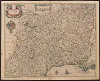
Jean Cóvens et Corneille Mortier,
Subject (Geographic):
Namur (Belgium)--Maps--Early works to 1800
Found in:
Beinecke Rare Book and Manuscript Library > Comitatus Namurcensis cum Finitimis Regionibus ad Usum Serenissimi Burgundiae Ducis.
Published / Created:
[1670?]
Call Number:
3325 Ar62 1670
Container / Volume:
BRBL_00081
Image Count:
1
Resource Type:
Maps, Atlases & Globes
Description:
Preliminary record.
Publisher:
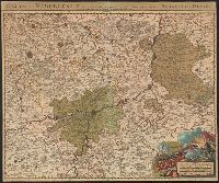
F. de Wit,
Subject (Geographic):
Arnhem (Netherlands)--Maps--Early works to 1800 and Gelderland (Netherlands)--Maps--Early works to 1800
Found in:
Beinecke Rare Book and Manuscript Library > Ducatus Geldriae Tetrachia Arnhemiensis sive Velavia.
Published / Created:
[1680?]
Call Number:
3615 1680
Container / Volume:
BRBL_00135
Image Count:
1
Resource Type:
Maps, Atlases & Globes
Description:
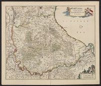
Lower Rhine Linz to Holland.
Publisher:
per Nicolaum Visscher,
Subject (Geographic):
Rhine River--Maps--Early works to 1800
Found in:
Beinecke Rare Book and Manuscript Library > Juliacensis, Cliviensis, et Montensis Ducatus, nec non Coloniensis Archiepiscopatus et Aliae Regiones proxime Rhenum Fluvium adjacentes ...
Creator:
Published / Created:
[1742]
Call Number:
1977 Folio 177
Image Count:
2
Resource Type:
Maps, Atlases & Globes
Alternative Title:
Nova Electoratus Brandenburgici tabula edita per I.P. Fr. von Gundling
Description:
"G.P. Busch sculpsit"., From Guillaume de L'Isle's Atlas nouveau., Includes illustrated cartouches., Prime meridian: Ferro., Relief shown pictorially., Shows settlements, universities, roads, forests, rivers, etc., and Title in ms. on verso. Stamp on verso: 305. Sheet measures 54.2 x 67.5 cm. No. 28 of 34 maps bound together.
Publisher:
Bey Johannes Covens und Cornelius Mortier,
Subject (Geographic):
Brandenburg (Germany)--Maps--Early works to 1800 and Poland--Maps--Early works to 1800
Found in:
Beinecke Rare Book and Manuscript Library > Land-Charte des Chur-Fürstenthums Brandenburg [cartographic material].
Published / Created:
[1700?]
Call Number:
38 L26 1700
Container / Volume:
BRBL_00157
Image Count:
2
Resource Type:
Maps, Atlases & Globes
Publisher:
Blaeuw excudit.,
Subject (Geographic):
Langres (France)--Maps--Early works to 1800
Found in:
Beinecke Rare Book and Manuscript Library > Langredoc.
Published / Created:
[1633]
Call Number:
217 1633
Image Count:
2
Resource Type:
Maps, Atlases & Globes
Description:
Negative on file. and Preliminary record.
Publisher:
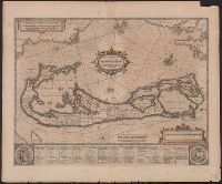
H. Hondius,
Subject (Geographic):
Bermuda Islands--Maps--Early works to 1800
Found in:
Beinecke Rare Book and Manuscript Library > Mappa Aestivarum insularum, alias Barmudas ...
Branch:v1.61.6 ,Deployed:2024-06-12T09:55:33-04:00