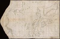
Color: pen and ink with green and blue shading., In the corner there is a table of the Florida and Cuban cays with their locations on the map. On the Island of Jamaica is marked Pta. Portland, presumably named after the Earl of Portland, councillor for trade and navigation, who died in 1663, or his son, who was killed fighting the Dutch in the battle off the Texel in 1665., On Jamaica the name "Kiniston" (Kingston) has been added early on, presumably about 1695, soon after its foundation, and in Hayti the name St. Luiz at a later period., and Spanish manuscript portolan chart on vellum. Unsigned and undated.
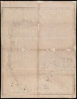
Carta Esferica que comprende las costas del Seno Mexicano construida de ordes del Rey en el deposito hidrografico de marina.
Description:
Backed with paper., Imperfect: mutilated along folds., Possibly copied from a Spanish chart "Carta Esferica que comprende las costas del Seno Mexicano construida de ordes del Rey en el deposito hidrografico de marina.", and Relief shown by hachures; depth by soundings.
Subject (Geographic):
Mexico, Gulf of--Maps.
Subject (Topic):
Coasts--Mexico--Maps. and Nautical charts--Mexico, Gulf of.
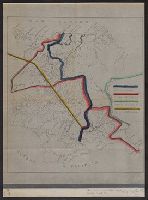
Boundary lines noted in hand-colored ink., Ms. notes along bottom right margin: "Taken from map without title, property of the United Fruit Co.", and Positive photostat.
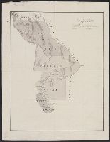
From the Streeter collection., Pen-and-ink and watercolor., Relief shown by hachur, Shows "Partido del Paso," "Partido de Aldama," and "Partido de Rosales," with New Mexico to the north and Coahuila and Texas to the east., Spanish., and Title devised by cataloger.
Subject (Geographic):
Chihuahua (Mexico : State)--Maps, Manuscript, Coahuila and Texas (Mexico)--Maps, Manuscript, and New Mexico--Maps, Manuscript
Luisiana, aņo de 1798, sur d'oueste de la ciudad. and Plano de la ciudad de Nueva Orleans.
Description:
"Luisiana, año de 1798, sur d'oueste de la ciudad," in French, Spanish and English, dated Marzo, 16 de 1798, and signed: Carlos Trudeau., "Plano de la ciudad de Nueva Orleans" in French and Spanish, dated 6 de Agosto 1799, and signed at end: Carlos Trudeau., At foot of map, "Luisiana, año de 1798 ... ": Recorded in the Book No. 3, page 216, New Orleans, juin 3th 1808. Van Pradelles ..., Maps are hand colored. Old fold marks visible., and Two folding plans of New Orleans by Charles Trudeau; to accompany Thierry's Examen des droits des Etats Unis ... , Nouvelle-Orleans, De l'imprimerie de Thierry & Co., 1808.
Publisher:
s.n.,
Subject (Geographic):
New Orleans (La.)--Maps
Subject (Name):
Thierry, J. B. S. (Jean Baptiste Simon), d. 1815. Examen des droits des Etats-Unis et des pretentions de Mr. Edouard Livingston sur la batture en face du faubourg Ste. Marie. and Thierry, J. B. S.--(Jean Baptiste Simon),--d. 1815.--Examen des droits des Etats-Unis et des pretentions de Mr. Edouard Livingston sur la batture en face du faubourg Ste. Marie.