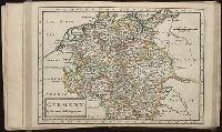
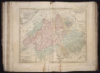
Twenty four new and accurate maps of the several parts of Europe ... : all (except the last) new
Image Count:
1
Alternative Title:
Germany in general
Description:
In pencil on verso: 7.
Subject (Geographic):
Germany --Maps --Early works to 1800
Subject (Name):
Barker, B. (Benjamin), d. 1764, bookseller, Clements, Henry, d. 1719, bookseller, King, Charles, d. 1735, bookseller, Nicholson, John, d. ca. 1717, bookseller, Parker, Richard, fl. 1692-1725, bookseller, and Tooke, Benjamin, d. 1716, bookseller
Subject (Topic):
Atlases --Early works to 1800
Collection Created:
[London] : Sold by J. Nicholson at the King’s-Arms in Little Britain, Benj. Barker and Charles King ..., Benj. Tooke ..., Hen. Clements ..., R. Parker and Ralph Smith under the Royal-Exchange ..., [1715?]
Bar scales given in mill. Germanica sive geometrica 15 in uno gradu and milliaria Gallica magna sive horae itineris., No. 14 of 69 maps bound together in composite atlas., Relief shown pictorially., and Scale [ca. 1:680 000].
Delarochette, L. (Louis), 1731-1802, creator Faden, William, 1749-1836 Meta, C. Palmer, W. (William), 1739-1812
Published / Created:
1790 January 1
Call Number:
1982 Folio 10
Image Count:
1
Description:
Also appeared in Faden's [General atlas. London : William Faden, 1811?]., Includes illustrated cartouche C. Meta fec., No. 28 of 43 maps bound together in composite atlas., Relief shown pictorially., and Scale [ca. 1:1,350,000].
Publisher:
Willm. Faden
Subject (Geographic):
Greece --Maps --Early works to 1800 and Turkey --Maps --Early works to 1800
Bar scales given in Italian miles and com[m]on leagues of France., I. Harris, sc., Longitude east from London., No. 18 of 69 maps bound together in composite atlas., Relief shown pictorially., and Scale [ca. 1:2 300 000].
Publisher:
Improved and sold by Robt. Morden and Christopr. Browne at the Atlas in Cornhill and the Globe ye Westend of St. Pauls
Subject (Geographic):
Italy --History --1559-1789 --Maps and Italy --Maps --Early works to 1800
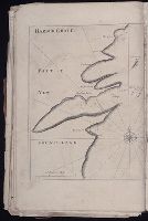
The English pilot: describing the sea-coasts, capes, head-lands, rivers, bays, roads, havens
Image Count:
2
Description:
Most maps numbered in pencil on verso, some on recto.
Subject (Geographic):
Atlantic Ocean --Maps --Early works to 1800 and Newfoundland and Labrador --Maps --Early works to 1800
Subject (Topic):
Navigation --Early works to 1800, Pilot guides --Atlantic Coast (U.S.) --Early works to 1800, and Pilot guides --Caribbean Area --Early works to 1800
Collection Created:
London : Printed for John Thornton, at the sign of the England, Scotland, and Ireland, in the Minories, and Richard Mount, at the Postern on Tower-Hill, 1698London : Printed for John Thornton, at the sign of the England, Scotland, and Ireland, in the Minories, and Richard Mount, at the Postern on Tower-Hill, 1698