Search
You Searched For
Search Results
- Creator:
- Maury, Matthew Fontaine, 1806-1873
- Published / Created:
- 1852
- Call Number:
- 11cfk 1850C-9
- Container / Volume:
- BRBL_00772
- Image Count:
- 2
- Resource Type:
- Maps, Atlases & Globes
- Found in:
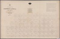
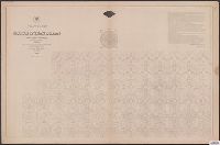
- Beinecke Rare Book and Manuscript Library > Pilot chart for Cape Horn [cartographic material] / by M.F. Maury, L.L.D. Lieut. U.S. Navy, Superin'dt. of U.S.N. Observatory ; compiled from materials in the Bureau of Ordnance and Hydrography, Commodore Charles Morris, Chief of Bureau.
- Creator:
- Maury, Matthew Fontaine, 1806-1873
- Published / Created:
- 1852
- Call Number:
- 11cfk 1850C-9
- Container / Volume:
- BRBL_00772
- Image Count:
- 2
- Resource Type:
- Maps, Atlases & Globes
- Found in:
- Beinecke Rare Book and Manuscript Library > Pilot chart for Cape Horn [cartographic material] / by M.F. Maury, L.L.D. Lieut. U.S. Navy, Superin'dt. of U.S.N. Observatory ; compiled from materials in the Bureau of Ordnance and Hydrography, Commodore Charles Morris, Chief of Bureau.
- Creator:
- Maury, Matthew Fontaine, 1806-1873
- Published / Created:
- 1851-1859.
- Call Number:
- 11cfk 1850C-6
- Container / Volume:
- BRBL_00771
- Image Count:
- 10
- Resource Type:
- Maps, Atlases & Globes
- Found in:
- Beinecke Rare Book and Manuscript Library > Pilot chart of the South Pacific [cartographic material] / by M.F. Maury, L.L.D., Lieut. U.S. Navy ; Superin'dt. of U.S.N. Observatory ; compiled from materials in the Bureau of Ordnance and Hydrography, Commodre Charles Morris, Chief of Bureau.
- Creator:
- Maury, Matthew Fontaine, 1806-1873
- Published / Created:
- 1854
- Call Number:
- 11cfk 1850C-8
- Container / Volume:
- BRBL_00772
- Image Count:
- 1
- Resource Type:
- Maps, Atlases & Globes
- Found in:
- Beinecke Rare Book and Manuscript Library > Pilot chart of the coast of Brazil [cartographic material] / by Lieut. M.F. Maury, U.S. Navy, National Observatory ; eng. by Sherman & Smith.
- Creator:
- Maury, Matthew Fontaine, 1806-1873
- Published / Created:
- 1855
- Call Number:
- 11cfk 1850C-11
- Container / Volume:
- BRBL_00772
- Image Count:
- 1
- Resource Type:
- Maps, Atlases & Globes
- Found in:
- Beinecke Rare Book and Manuscript Library > Pilot chart of the north Indian Ocean [cartographic material] / by M.F. Maury, L.L.D. Lieut. U.S. Navy, Superin'dt. of U.S.N. Observatory ; compiled from materials in the Bureau of Ordnance and Hydrography by Lieuts. W.B. Fitzgerald & Wm. C. West, U.S.N, Commodore Charles Morris, Chief of Bureau.
- Creator:
- Maury, Matthew Fontaine, 1806-1873
- Published / Created:
- 1851
- Call Number:
- 11DB 1851A-1
- Container / Volume:
- BRBL_00774
- Image Count:
- 1
- Resource Type:
- Maps, Atlases & Globes
- Found in:
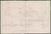
- Beinecke Rare Book and Manuscript Library > Whale chart [cartographic material] : preliminary sketch / by M.F. Maury, A.M. Lieut., U.S. Navy ; constructed by Lts. Leigh. Herndon & Fleming & Pd. Midn. Jackson.
- Creator:
- Maury, Matthew Fontaine, 1806-1873
- Published / Created:
- 1850
- Call Number:
- 11cfk 1850D-1
- Container / Volume:
- BRBL_00773
- Image Count:
- 4
- Resource Type:
- Maps, Atlases & Globes
- Found in:
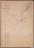
- Beinecke Rare Book and Manuscript Library > Wind and current chart of the North Atlantic [cartographic material] : thermal sheet / by M.F. Maury, A.M. Lieut. U.S. Navy, Superint'dt. of U.S.N. Observatory ; compiled from materials in the Bureau of Ordnance and Hydrography, Commodore Lewis Warrington, Chief of Bureau ; drawn by Lt. Benjn. S. Gantt, U.S.N.
- Creator:
- Maury, Matthew Fontaine, 1806-1873
- Published / Created:
- 1850
- Call Number:
- 11cfk 1850D-1
- Container / Volume:
- BRBL_00773
- Image Count:
- 8
- Resource Type:
- Maps, Atlases & Globes
- Found in:
- Beinecke Rare Book and Manuscript Library > Wind and current chart of the North Atlantic [cartographic material] : thermal sheet / by M.F. Maury, A.M. Lieut. U.S. Navy, Superint'dt. of U.S.N. Observatory ; compiled from materials in the Bureau of Ordnance and Hydrography, Commodore Lewis Warrington, Chief of Bureau ; drawn by Lt. Benjn. S. Gantt, U.S.N.