Skip to search
Skip to main content
Skip to first result
Search
You Searched For
Genre
Maps
Language
English
New Search
Search Results
Published / Created:
1714
Call Number:
327 1714
Container / Volume:
BRBL_00072
Image Count:
1
Resource Type:
Maps, Atlases & Globes
Description:
Insets: The Isle of St. Patrick's Purgatory, Gyants Cawsway, Waterford, Gallway, Kinsale, Limrick, Dublin, Corke.
Publisher:
T. Bowles,
Subject (Geographic):
Ireland--Maps--Early works to 1800
Found in:
Beinecke Rare Book and Manuscript Library > A new map of Ireland ... Herman Moll, Geographer 1714.
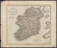
Published / Created:
1799
Call Number:
327 1799
Container / Volume:
BRBL_00073
Image Count:
1
Resource Type:
Maps, Atlases & Globes
Publisher:
J. Cary,
Subject (Geographic):
Ireland--Maps--Early works to 1800
Found in:
Beinecke Rare Book and Manuscript Library > A new map of Ireland ... by John Cary, Engraver.
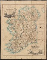
Published / Created:
1811
Call Number:
327 1811
Container / Volume:
BRBL_00073
Image Count:
1
Resource Type:
Maps, Atlases & Globes
Description:
Preliminary record.
Publisher:
J. Cary,
Subject (Geographic):
Ireland--Maps
Found in:
Beinecke Rare Book and Manuscript Library > A new map of Ireland ... by John Cary, Engraver.
Published / Created:
1793
Call Number:
327 1793
Container / Volume:
BRBL_00072
Image Count:
1
Resource Type:
Maps, Atlases & Globes
Publisher:
W. Faden,
Subject (Geographic):
Ireland--Maps--Early works to 1800
Found in:
Beinecke Rare Book and Manuscript Library > A new map of Ireland ... distances between the Towns & Stages, marked in miles and furlongs ... by Alexander Taylor ... Royal Engineers.
Creator:
Published / Created:
1792
Call Number:
1982 Folio 10
Image Count:
2
Description:
No. 7 of 43 maps bound together in composite atlas. and Scale [1:500,000].
Publisher:
W. Faden & W. Allen
Subject (Topic):
Parishes --Ireland --Maps
Found in:
Beinecke Rare Book and Manuscript Library > A new map of Ireland, civil and ecclesiastical
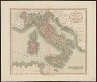
Published / Created:
1799
Call Number:
40 1799
Container / Volume:
BRBL_00198
Image Count:
1
Resource Type:
Maps, Atlases & Globes
Publisher:
Publish'd by J. Cary ... ,
Subject (Geographic):
Italy--Maps--Early works to 1800
Found in:
Beinecke Rare Book and Manuscript Library > A new map of Italy ... / by John Cary, engraver.
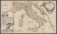
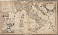
Published / Created:
1714
Call Number:
40 1714A
Container / Volume:
BRBL_00197
Image Count:
1
Resource Type:
Maps, Atlases & Globes
Description:
Insets: Mt. Vesuvius, Mt. Aetna.
Publisher:
T. Bowles ... ,
Subject (Geographic):
Italy--Maps--Early works to 1800
Found in:
Beinecke Rare Book and Manuscript Library > A new map of Italy ... post roads ... / H. Moll, geographer.
Creator:
Published / Created:
1708
Call Number:
40 1708
Container / Volume:
BRBL_00684
Image Count:
1
Resource Type:
Maps, Atlases & Globes
Description:
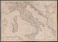
"C. Price delin. I. Senex sculp"., Appears in Senex's A new general atlas, 1721., Decorative title cartouche, with classical figures., Dedicated to Humphrey Mackworth., Imperfect: mutilated, with some loss of text; "C. Prince delin." scratched out. Ms. no. on verso: 19. Backed with paper. Sheet measures 69 x 97 cm. Cross Collection no. 94., London meridian., Relief shown pictorially., and Shows boundaries, rivers, roads, and settlements.
Publisher:
John Senex],
Subject (Geographic):
Italy--Maps--Early works to 1800
Subject (Name):
Mackworth, Humphrey, Sir, 1657-1727, dedicatee, Price, Charles, fl. 1700-1707, and Senex, John, d. 1740. New general atlas
Found in:
Beinecke Rare Book and Manuscript Library > A new map of Italy : corrected from the observations communicated to ye Royal Society at london and ye Royal Accademy [sic] at Paris / by Iohn Senex.
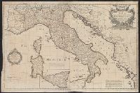
Published / Created:
[ca. 1760]
Call Number:
40 1780C
Container / Volume:
BRBL_00198
Image Count:
2
Resource Type:
Maps, Atlases & Globes
Description:
Dedication under coat of arms inscribed Honi Soit Qui Mal y Pense: To His Most Sacred Majesty George by the grace of God King of Great Britain, France and Ireland &c. this map is most humbly dedicated by His Majesty's most loyal & obedient subject and ser
Publisher:
Robt. Sayer at the Golden Buck in Fleet Street,
Subject (Geographic):
Italy--Administrative and political divisions--Maps--Early works to 1800 and Italy--Maps--Early works to 1800
Subject (Name):
Overton, Henry, 1675 or 6-1751 and Sayer, Robert, 1725-1794
Found in:
Beinecke Rare Book and Manuscript Library > A new map of Italy : distinguishing all the sovereignties in it whether states, kingdoms, dutchies, principalities, republicks &c. with the post roads, & many remarks not extant in any map, according to the newest and most exact observations.
Branch:v1.61.6 ,Deployed:2024-06-12T09:55:33-04:00