Rand-McNally indexed pocket map and shippers' guide of Kansas
Description:
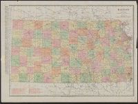
"Showing all railroads, cities, towns, villages, postoffices, lakes, rivers, etc."--Cover of text., Indexed., Library's copy missing text., Relief shown by hachures., and Shows railroads, military reservations, postal and express services.
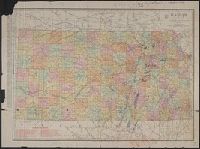
Below scale: Rand McNally & Co.'s new business atlas map of Kansas. Copyright 1911 ... Copyright 1903 ...., Imperfect. Chipped with some loss of text: Ms. annotations to indicate oil fields and drilling., Indexed on verso., Indexed., Relief shown by hachures., and Shows counties and railroads.
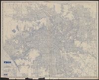
Copyright: Rand McNally & Company., In lower right: Y.3897., Includes inset of "Pacific Palisades.", and Indexes, "Los Angeles and vicinity (recreational map)," (scale [ca. 1:323,136]), and ill. on verso.
Publisher:
Rand McNally & Co.,
Subject (Geographic):
Los Angeles (Calif.)--Maps and Los Angeles Metropolitan Area (Calif.)--Maps
Subject (Name):
Union Oil Company of California
Subject (Topic):
Roads--California--Los Angeles Metropolitan Area--Maps and Streets--California--Los Angeles--Maps
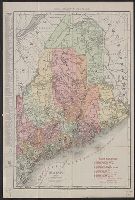
Rand McNally & Co.'s new business atlas map of Maine. and Rand-McNally indexed atlas.
Description:
Includes key to railroads., Indicates electric lines and steamship lines., Relief shown by hachures., and Title from copyright statement: Rand, McNally & Co.'s new business atlas map of Maine.
Publisher:
Rand, McNally & Co.,
Subject (Geographic):
Maine--Maps
Subject (Topic):
Electric lines--Maine--Maps, Railroads--Maine--Maps, and Steamboat lines--Maine--Maps
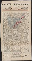
Above upper margin: "Cross section of the property owned by the Fort Payne Coal & Iron Company, showing coal measures and red hematite ore" and Attached to map: Showing location of Mammoth Vein. Ca. 1:15,000, 13x22.
Publisher:
Rand, McNally & Co.,
Subject (Geographic):
Alabama--Maps
Subject (Name):
Fort Payne Coal & Iron Company
Subject (Topic):
Coal mines and mining--Alabama--Maps, Iron mines and mining--Alabama--Maps, and Real property--Alabama--Maps
Argentine Republic, Paraguay, Uruguay, & Chile and Rand McNally & Co's indexed Atlas of the World :
Description:
At head of title: Rand McNally & Co's indexed Atlas of the World., Includes 3 inset maps: St. Felix and St. Ambrose islands, Juan Fernandez I., and "Southern portion of Chile and Argentine Republic.", Relief shown by hachures., and Shows railroads completed and railroads projected.