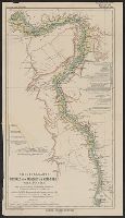
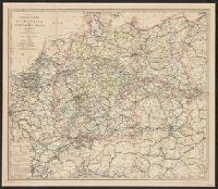
Stieler's Hand-Atlas ; no.69 and Stieler's Hand-Atlas no.69.
Description:
Inset maps (scale 1:7,500,000) of Senegambia, Sierra Leone, and the Gold Coast., Meridian also noted from Paris and Ferro., and Relief shown by hachures and spot heights.
Publisher:
Justus Perthes,
Subject (Geographic):
Africa, Northwest--Maps
Subject (Name):
Habenicht, Hermann (1844-1917), Hanemann, Fritz, Kramer, A, and Kühn, E
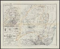
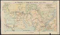
Ergänzungsheft ... zu Petermanns geographischen Mitteilungen. and Transvaal or South-African Republik
Description:
"From surveys and observations by Survr. Genl. M. Forssmann, C. Mauch, F. Hammar, Survr. J. Brooks, and other official documents, combined with the results of their own explorations by F. Jeppe and A. Merensky, Potchefstroom & Botsabelo, 1868." and In top mar
"Langhans: Beiträge zur Kenntnis der deutschen Schutzgebiete, Nr. 18.", "Petermann's geographische Mitteilungen. Jahrgang 1902, Tafel 7.", Includes inset: Alexander Ross' eigene Karte., and Relief shown by hachures.
Publisher:
Justus Perthes,
Subject (Geographic):
Cameroon--Discovery and exploration--Maps
Subject (Name):
Justus Perthes (Firm : Gotha, Germany) and Ross, Alexander--Travel--Maps