Map II. This map includes the region from Resaca on the north to Ackworth [sic] on the south and exhibits the works of the United States and Confederate forces (1864).
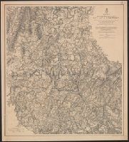
Map III. This map includes the region extending from Rome, Kingston, and Cassville on the north to include Dallas and Marietta on the south and exhibits the works of the United States and Confederate forces (1864)
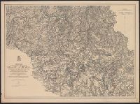
Map IV. Embracing the region from Pine, Lost, and Kennesaw Mountains south to include Atlanta and its environs, exhibiting the lines of operations at Pine, Lost, and Kennesaw Mts., at Smyrna Camp Ground a and Ms. notations in blue and red pencil.
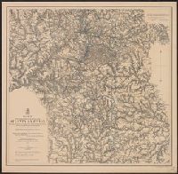
Map V. This map includes the region from the Chattahoochee River south to Jonesboro and Lovejoy's Station and exhibits the works of the United States and Confederate forces (1877). and MS. notations in blue and red pencil.
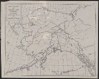
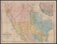
Tanner's travelling map of California &c, Travelling map of California, and United States, Mexico &c, showing the routes from N. York to St. Francisco by land & water.
Description:
Includes inset of "United States, Mexico &c, showing the routes from N. York to St. Francisco by land & water.", Library's copy 2 mounted on linen, without cover., Relief shown by hachures., Shows the New Southwest and parts of Texas and Mexico., and Text inside front cover, "Table of routes from New-York to California with the modes of conveyance, distances, time and fares."
Publisher:
H.S. Tanner,
Subject (Geographic):
California--Gold discoveries--Maps, California--Maps, Mexico--Maps, and Southwest, New--Maps