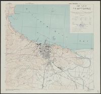
Great Britain. War Office. General Staff. Geographical Section
Published / Created:
1942
Call Number:
67 M45 1942
Container / Volume:
BRBL_00348
Image Count:
1
Resource Type:
Maps, Atlases & Globes
Alternative Title:
Morocco 10 000.
Description:
"Contours at 2.5 metres interval.", Earlier edition issued under title: Ville de Mazagan, 1:10,000, G. S. G. S. 4241., Important streets and buildings are named., In upper margin: Morocco 1:10,000 ..., and Military grid.
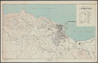
Great Britain. War Office. General Staff. Geographical Section
Published / Created:
1943
Call Number:
679 T15 1943
Container / Volume:
BRBL_00349
Image Count:
1
Resource Type:
Maps, Atlases & Globes
Alternative Title:
Geographical Section, General Staff ; no. 4241 and GSGS (Series) ; 4241.
Description:
"Contours at 5 metres interval.", "Key to numbers" lists points of interest; principal streets are named., "Published by War Office, 1941. 2nd edition, 1942. Revised by A. M. S. December 1942.", In upper margin: Morocco ..., and Military grid.
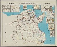
Great Britain. War Office. General Staff. Geographical Section
Published / Created:
1943
Call Number:
685gm 1943
Container / Volume:
BRBL_00351
Image Count:
2
Resource Type:
Maps, Atlases & Globes
Alternative Title:
Geographical Section, General Staff ; no. 4408 and GSGS (Series) ; 4408.
Description:
"Copied from an Italian map date 1940, compiled by Sezione topografica del fronti Tunisini.", "Published by War Office, 1943.", Insets: Ghardimaou.--Nefza.--Souk-el-Arbd.--Souk, and Twelve classes of roads and tracks, and three gauges of railroads are indicated.