Appears in Jansson's historical atlas editions from 1652-1684 and in his Accuratissima orbis antiqui delineatio. From 1653 on, this work is known under the name of Hornius, who wrote the text and compiled all the maps for the atlases--(Koeman-Krogt. 1:601-1:607)., Coordinates not present on map and are approximated., Inset: Itinera et mansiones deserti., Map indexed with grid lines and alphabet letters A-H at top., Oriented with north toward the left., Relief shown pictorially., Shows greater part of the Tribe of Judah, with Biblical illustrations., and Watermark. Manuscript number in upper left corner: 48. No. 5 of 6 maps housed together.
Publisher:
[Jan Jansson],
Subject (Geographic):
Palestine--History--To 70 A.D.--Maps--Early works to 1800. and Palestine--Maps--Early works to 1800.
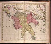
Appeared in Valk and Schenk's Atlantis sylloge compendiosa, ca. 1702., Backed with paper. Ms. no. "84" in upper right-hand corner. Sheet measures 53.3 x 61.5 cm. No. 78 of 87 maps bound together., Bar scales given in "milliaria Italica" and "milliaria Germanica.", Prime meridian: Ferro., Relief shown pictorially., and Watermark.
Publisher:
Sumptibus Gerardi et Leonardi Valk, cum privil,
Subject (Geographic):
Peloponnesus (Greece)--Maps--Early works to 1800.
Subject (Name):
Schenk, Peter, 1660-1718 or 1719. Atlantis sylloge compendiosa. and Valck, G. (Gerard), 1651 or 1652-1726. Atlantis sylloge compendiosa.
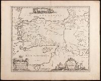
Bar scale given in "milliaria Germanica communia"., From Joan Blaeu's Théâtre du monde (1643-1650)., In French on verso with caption title "Tatarie," paginated "8," and with signature H., and Relief shown pictorially.
Publisher:
[Willem Janszoon Blaeu],
Subject (Geographic):
Asia, Central--Maps--Early works to 1800. and Siberia, Eastern (Russia)--Maps--Early works to 1800.
Subject (Name):
Blaeu, Joan, 1596-1673. Theatrum orbis terrarum. French.
"Amstel. cum priv. D.D. Ord. Holl. et West-Fr.", Appears in various editions of Wit's Atlas., Hand colored in outline., Illustrated hand colored title cartouche; sea decorated with ships., Imperfect: chipped and torn, with some loss of text. Backed with paper., Prime meridian: Ferro., and Relief shown pictorially.
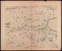
Tribvs Aser, et partes occidentales tribuum Zabvlon et Isachar
Description:
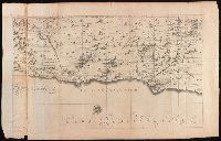
Appears in Jansson's historical atlas editions from 1652-1684 and in his Accuratissima orbis antiqui delineatio. From 1653 on, this work is known under the name of Hornius, who wrote the text and compiled all the maps for the atlases--(Koeman-Krogt. 1:601-1:607)., Coordinates not present on map and are approximated., Map indexed with grid lines and alphabet letters A-H at bottom., Oriented with north toward the left., Printed on one and a half sheets., Relief shown pictorially., Shows the Tribe of Asher and the western parts of Zabulon and Isachar., and Watermark. Manuscript numbers in upper left and right corners: 43. No. 3 of 6 maps housed together.
Publisher:
[Jan Jansson],
Subject (Geographic):
Palestine--History--To 70 A.D.--Maps--Early works to 1800. and Palestine--Maps--Early works to 1800.
Tribuum Ephraim, Beniamin, et Dimidiae, Manasse intra Jordanem partes occidentales, et partes septentrionales Dan et Juda
Description:
Appears in Jansson's historical atlas editions from 1652-1684 and in his Accuratissima orbis antiqui delineatio. From 1653 on, this work is known under the name of Hornius, who wrote the text and compiled all the maps for the atlases--(Koeman-Krogt. 1:601-1:607)., Coordinates not present on map and are approximated., Map indexed with grid lines and alphabet letters I[J]-O at bottom., Oriented with north toward the left., Relief shown pictorially., and Watermark. Manuscript number in upper left corner: 44. No. 2 of 6 maps housed together.
Publisher:
[Jan Jansson],
Subject (Geographic):
Palestine--History--To 70 A.D.--Maps--Early works to 1800. and Palestine--Maps--Early works to 1800.
Tribus Ruben, et Gad et partes orientales tribuum Benjamin, Ephraim, et dimidiae Manasse intra Jordanem
Description:
Appears in Jansson's historical atlas editions from 1652-1684 and in his Accuratissima orbis antiqui delineatio. From 1653 on, this work is known under the name of Hornius, who wrote the text and compiled all the maps for the atlases--(Koeman-Krogt. 1:601-1:607)., Coordinates not present on map and are approximated., Includes many biblical scenes and notes., Manuscript number in upper left corner: 47. No. 1 of 6 maps housed together., Map indexed with grid lines and alphabet letters J-O at top of map under title., Map of the Hebrew tribes of Reuben and Gad, with the eastern parts of the tribes of Benjamin, Ephraim, and half of Manasseh beyond the Jordan River., Oriented with north to the left., Relief shown pictorially., and The first map drawn of a series of six sheets that form an enlarged adaptation of Andrichom's "Sitius Terrae Promissionis". This map is the sheet positioned at top, center.
Publisher:
[Jan Jansson],
Subject (Geographic):
Middle East--Palestine. and Palestine--History--To 70 A.D.--Maps--Early works to 1800.
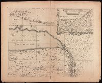
Tribus Simeon et pars meridionalis tribus Dan, et orientalis tribus Juda
Description:
Appears in Jansson's historical atlas editions from 1652-1684 and in his Accuratissima orbis antiqui delineatio. From 1653 on, this work is known under the name of Hornius, who wrote the text and compiled all the maps for the atlases--(Koeman-Krogt. 1:601-1:607)., Coordinates not present on map and are approximated., Map indexed with grid lines and alphabet letters P-V at bottom., Oriented with the north toward the left., Relief shown pictorially., Shows the tribe of Simeon, the southern part of the tribe of Dan, and the eastern part of Judah. Many Biblical illustrations on map., and Watermark. Manuscript number in upper left corner: 45. No. 6 of 6 maps housed together.
Publisher:
[Jan Jansson],
Subject (Geographic):
Palestine--History--To 70 A.D.--Maps--Early works to 1800. and Palestine--Maps--Early works to 1800.