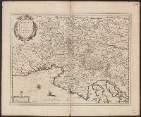
Bar scale given in "milliaria Italica communia"., From Blaeu's Theatrum orbis terrarum, 1635., In Latin on verso; with caption title "Descriptio Karstiae, Carniolae, Windorum marchiae, comitatus Ciliae fori Iulii, necnon Istriae" and signature K., and Relief sho
Publisher:
Guiljelm. Blaeu excudit,
Subject (Geographic):
Carniola (Slovenia)--Maps--Early works to 1800 and Croatia--Maps--Early works to 1800
Subject (Name):
Blaeu, Joan, 1596-1673. Theatrum orbis terrarum and Blaeu, Willem Janszoon, 1571-1638. Theatrum orbis terrarum
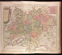
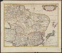
Russiae, Albae, sive Moscoviae delineatio geographica accurata et nova
Description:
Appeared in Peter Schenk's Atlas contractus [ca. 1700]., BEIN 1973 Folio 18: Backed with paper. Ms. no. "4" in upper right-hand corner. Sheet measures 53.4 x 62.0 cm. No. 3 of 87 maps bound together., Includes six bar scales., Prime meridian: Ferro., and Relief shown pictorially.
Publisher:
Studio et labore Petr. Schenck,
Subject (Geographic):
Europe, Eastern--Maps--Early works to 1800. and Russia--Maps--Early works to 1800.
Subject (Name):
Schenk, Peter, 1660-1718 or 1719. Atlas contractus.
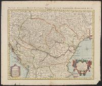
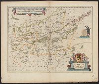
"Avec privilege"., Appeared in Cóvens et Mortier's Nieuwe atlas., Imperfect: torn along bottom fold, with no loss of text. Ms. no. above neat line: 25. Sheet measures 55.3 x 65.7 cm., Includes four bar scales., Prime meridian: Ferro, and Relief shown pictorially.
Publisher:
Chez I. Còvens et C. Mortier,
Subject (Geographic):
Balkan Peninsula--Maps--Early works to 1800 and Hungary--Maps--Early works to 1800
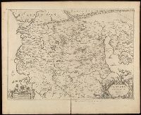
Relief shown pictorially., Verso blank., and Watermark. Manuscript number in upper left corner: 27. Manuscript annotations below neat line.
Publisher:
[Jan Jansson],
Subject (Geographic):
Albania, Albania--Maps--Early works to 1800., Europe--Macedonia, Greece--Maps--Early works to 1800., Macedonia (Republic)--Maps--Early works to 1800., and Macedonia--Maps--Early works to 1800.
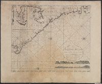
Appears in J. van Keulen's De nieuwe groote lichtende zee-fakkel., Copy 2: Not colored., In bottom right: 7., Includes 2 coastal profiles, 2 insets, and rhumb lines., Oriented with north to the left., and Relief shown pictorially. Depths shown by soundings.
Publisher:
Gerard van Keulen, boek en zeekaart verkooper aen de Nieuwen Brugh,
Subject (Geographic):
Africa, Central--Maps--Early works to 1800 and Coasts--Africa, West--Maps--Early works to 1800
Subject (Name):
Keulen, Johannes van, fl. 1726-1753. Nieuwe groote lichtende zee-fakkel
Subject (Topic):
Nautical charts--Africa, Central--Early works to 1800
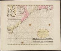
Appears in J. van Keulen's De nieuwe groote lichtende zee-fakkel., In bottom right: 7., Includes 2 coastal profiles, 2 insets, and rhumb lines., Oriented with north to the left., and Relief shown pictorially. Depths shown by soundings.
Publisher:
Gerard van Keulen, boek en zeekaart verkooper aen de Nieuwen Brugh,
Subject (Geographic):
Africa, Central--Maps--Early works to 1800 and Coasts--Africa, West--Maps--Early works to 1800
Subject (Name):
Keulen, Johannes van, fl. 1726-1753. Nieuwe groote lichtende zee-fakkel
Subject (Topic):
Nautical charts--Africa, Central--Early works to 1800
Nova & accurata Tusciae antiquae descriptio, Nova et accurata Tusciae antiquae descriptio, and Nova et accurata Tvsciae antiqvae descriptio
Description:
Appeared in various editions of Jan Jansson's Accuratissima orbis antiqui delineatio., Borders are hand colored., Coordinates not accurate as presented on map and are approximated., Manuscript number in upper left corner: 16., Relief shown pictorially., and Verso blank.
Publisher:
[Jan Jansson],
Subject (Geographic):
Tuscany (Italy)--Maps--Early works to 1800.
Subject (Name):
Jansson, Jan, 1588-1664. Accuratissima orbis antiqui delineatio. and Ortelius, Abraham, 1527-1598
Subject (Topic):
Historical geography--Italy--Tuscany--Maps--Early works to 1800.