Bowen, Emanuel, d. 1767 Cook, James, fl. 1766, creator
Published / Created:
Decr. 1766
Call Number:
2003 Folio 85
Image Count:
1
Description:
BEIN 2003 Folio 85: No. 24 of 45 maps bound together with binder's spine title: Atlas of America; ms. table of contents. Bookplate: Robinson. Bookplate of Paul Mellon., by their humble servt. James Cook ; approv'd of by Mr. Joiner 20 years a pilot of that place., Depths shown by soundings., Emanl. Bowen sculpt., Hand colored., and Scale [1:65,000].
Publisher:
By the author
Subject (Geographic):
Port Royal (S.C.) -- Maps -- Early works to 1800
Subject (Topic):
Nautical charts -- Port Royal (S.C.) -- Early works to 1800
Bowen, Emanuel, d. 1767 Cook, James, 1728-1779, creator
Published / Created:
Decem'r. 1766
Call Number:
2003 Folio 85
Image Count:
1
Description:
BEIN 2003 Folio 85: No. 15 of 45 maps bound together with binder's spine title: Atlas of America; ms. table of contents. Bookplate: Robinson. Bookplate of Paul Mellon., by James Cook, when surveyor of His Majesty's Ship the Mars., Depths shown by soundings., Eman'l. Bowen sculp't., Hand colored., and Scale [ca. 1:64,000].
Publisher:
Published by the author according to Act of Parliament
Subject (Geographic):
Halifax (N.S.) -- Maps -- Early works to 1800
Subject (Topic):
Coasts -- Nova Scotia -- Maps -- Early works to 1800 and Nautical charts -- Nova Scotia -- Early works to 1800
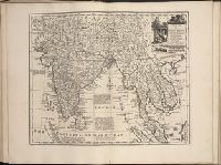
Bowen, Emanuel, d. 1767 Gibson, J. (John) Overton, Henry, fl. 1706-1764 Sayer, Robert, 1725-1794
Published / Created:
[between 1755 and 1775?]
Call Number:
2003 Folio 85
Image Count:
1
Description:
BEIN 2003 Folio 85: No. 4 of 45 maps bound together with binder's spine title: Atlas of America; ms. table of contents. Bookplate of Paul Mellon., by Eman. Bowen, geogr. to His Majesty, and John Gibson, engraver., Hand-colored., Includes text and insets of A particular map of Baffin and Hudson's Bay and The passage by land to California, discovered by Father Eusebius Francis Kino ...., Relief shown pictorially., Scale [ca. 1:5,500,000]., and Shows boundaries, cities and towns, roads, forts, missions, some industries, trails, trade routes, portages, and vegetation. Also shows Indian villages and tribal territories, routes of navigation in the Gulf of Mexico, and navigational hazards along the coast.
Publisher:
Printed for Robt. Sayer opposite Fetter Lane Fleet Street