Skip to search
Skip to main content
Skip to first result
Search
You Searched For
Resource Type
Maps, Atlases & Globes
Publication Place
Chicago :
New Search
Search Results
Creator:
Published / Created:
1868
Call Number:
834gme 1868
Container / Volume:
BRBL_00591
Image Count:
1
Resource Type:
Maps, Atlases & Globes
Description:
Bookplate: ex libris T W S [i.e. Thomas Winthrop Streeter]. and Relief shown by hachures.
Publisher:
Chicago Lithographing Co.,
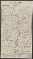
Subject (Name):
Chicago Lithographing Co, Denver Pacific Railway and Telegraph Company, Denver Pacific Railway and Telegraph Company--Maps, and Streeter, Thomas W.--(Thomas Winthrop),--1883-1965--Bookplate
Subject (Topic):
Railroads--Colorado--Maps
Found in:
Beinecke Rare Book and Manuscript Library > Denver Pacific Railway map showing the final location with prospective connections : compiled from railroad and gov't. surveys / F.M. Case.
Published / Created:
c1907.
Call Number:
32 1907
Container / Volume:
BRBL_00045
Image Count:
2
Resource Type:
Maps, Atlases & Globes
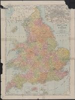
Description:
Inset: London and Environs 1:150,000.
Publisher:
Rand, McNally & Co.,
Subject (Geographic):
England--Maps and Wales--Maps
Found in:
Beinecke Rare Book and Manuscript Library > England & Wales.
Creator:
Published / Created:
[1914?]
Call Number:
30 1914
Container / Volume:
BRBL_00032
Image Count:
2
Resource Type:
Maps, Atlases & Globes
Publisher:
A. J. Nystrom,
Subject (Geographic):
Europe--Maps
Subject (Name):
A.J. Nystrom and Company
Found in:
Beinecke Rare Book and Manuscript Library > Europe.
Creator:
Published / Created:
1862, c1861.
Call Number:
75 1862C
Container / Volume:
BRBL_00403
Image Count:
1
Resource Type:
Maps, Atlases & Globes
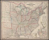
Alternative Title:
Guide map of the United States & Canada. and New Guide map of the United States & Canada.
Description:
Insets: Plan of the southern portion of Florida.--Western portion of the United States., Prime meridians: Greenwich, Washington., Relief shown by hachures., and Table: Population of the United States.
Publisher:
Colton ; and Rufus Blanchard,
Subject (Geographic):
United States--Maps and West (U.S.)--Maps
Subject (Name):
Blanchard, Rufus, 1821-1904
Found in:
Beinecke Rare Book and Manuscript Library > G. Woolworth Colton's new guide map of the United States & Canada : with railroads, counties etc. / drawn, engraved & published by G. Woolworth Colton.
Published / Created:
1892
Call Number:
806 C43 1892A
Container / Volume:
BRBL_00548
Image Count:
2
Resource Type:
Maps, Atlases & Globes
Alternative Title:
Official map of Chicago
Description:
Inset: large scale map Chicago business district.
Publisher:
A.N. Marquis & Co.,
Subject (Geographic):
Chicago (Illinois)--Maps
Found in:
Beinecke Rare Book and Manuscript Library > Handy small edition of A.N. Marquis & Co's Official map of Chicago.
Published / Created:
1915
Call Number:
812ag 1915
Container / Volume:
BRBL_00556
Image Count:
2
Resource Type:
Maps, Atlases & Globes
Alternative Title:
Hunting and fishing resorts of northwestern Wisconsin
Description:
"287" in bottom right margin., Includes wagon roads and trails as well as rail lines., and Verso: Hunting and fishing resorts of northern Wisconsin and Michigan, reached by the Chicago and North Western Railway. Copyright 1914 by Rand McNally & Co. Chicago.
Publisher:
Rand McNally & Co.,
Subject (Geographic):
Michigan--Maps and Wisconsin--Maps
Found in:
Beinecke Rare Book and Manuscript Library > Hunting and fishing resorts of northern Wisconsin and Michigan : reached by the Chicago and North Western Railway.
Creator:
Published / Created:
1911
Call Number:
832 1911A
Container / Volume:
BRBL_00582
Image Count:
1
Resource Type:
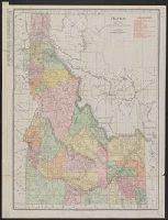
Maps, Atlases & Globes
Description:
Indexed., Relief shown by hachures., and Shows railroads.
Publisher:
Rand McNally,
Subject (Geographic):
Idaho--Maps
Subject (Topic):
Railroads--Idaho--Maps
Found in:
Beinecke Rare Book and Manuscript Library > Idaho / Rand McNally and Co.
Published / Created:
1899
Call Number:
807gmb 1899
Container / Volume:
BRBL_00551
Image Count:
1
Resource Type:
Maps, Atlases & Globes
Description:
"June 30, 1899". and Railroads operated by the Illinois Central R.R. Co. colored red ; Railroads operated by the Yazoo & Missisippi Valley R.R. Co., colored blue.
Publisher:
Rand McNally & Co.,
Subject (Geographic):
United States--Maps
Found in:
Beinecke Rare Book and Manuscript Library > Illinois Central Railroad : and Yazoo & Mississippi Valley Railroad.
Published / Created:
1905
Call Number:
754gme 1905
Container / Volume:
BRBL_00420
Image Count:
1
Resource Type:
Maps, Atlases & Globes
Description:
Shows lines and tracks of named railroads with the lngths of track in miles.
Publisher:
Rand McNally & Co.,
Subject (Geographic):
Illinois--Maps and Mississippi Valley--Maps
Found in:
Beinecke Rare Book and Manuscript Library > Illinois Central Railroad and Yazoo & Mississippi Valley Railroad. June 30th, 1905.
Published / Created:
[1944]
Call Number:
307hd 1944
Container / Volume:
BRBL_00036A
Image Count:
1
Resource Type:
Maps, Atlases & Globes
Publisher:
Chicago Sun,
Subject (Geographic):
Europe, Western--Maps
Found in:
Beinecke Rare Book and Manuscript Library > Invasion Map - reprinted from the Chicago Sun/ Map by Tom P. Barrett.
Branch:v1.61.6 ,Deployed:2024-06-12T09:55:33-04:00