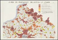
Institut national de la statistique et des études économiques (France)
Published / Created:
[1954]
Call Number:
38eb 1954A
Container / Volume:
BRBL_00170
Image Count:
9
Resource Type:
Maps, Atlases & Globes
Description:
"Exécutée par l'Imprimerie Nationale sur fond de carte du Ministère de la Construction.", Date from data in legend., and Includes index maps on each sheet and inset: Corse, on sheet 9.
Publisher:
Imprimerie Nationale,
Subject (Geographic):
France--Population--Maps
Subject (Topic):
Industries--France--Maps, Metropolitan areas--France--Maps, and Urbanization--France--Maps
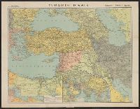
Map page from Atlas VIDAL-LABLACHE. Shows "Allied forces in black. Bolshevist forces in blue" with corresponding ms. notes on map. Ms. notes detail nationalities and commanders of individual forces and their placement. Map text in French, ms. notes in Eng