Skip to search
Skip to main content
Skip to first result
Search
You Searched For
Resource Type
Maps, Atlases & Globes
Publication Place
[Washington, D.C.] :
New Search
Search Results
Creator:
Published / Created:
1943
Call Number:
50ba 1943
Container / Volume:
BRBL_00274
Image Count:
1
Resource Type:
Maps, Atlases & Globes
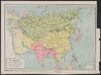
Description:
"28 Dec. 1943.", "Map no. 2870.", and Includes text.
Publisher:
Reproduction Branch, O.S.S.,
Subject (Geographic):
Asia--Distances, etc.--Maps and Pacific Ocean--Distances, etc.--Maps
Subject (Topic):
Azimuthal projection (Cartography)--Maps and Gnomonic projection (Cartography)--Maps
Found in:
Beinecke Rare Book and Manuscript Library > Eastern Asia and western Pacific Ocean, Gnomonic projection / compiled and drawn in the Branch of Research and Analysis, O.S.S.
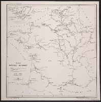
Creator:
Published / Created:
[1904]
Call Number:
50 1904A
Container / Volume:
BRBL_00273
Image Count:
1
Resource Type:
Maps, Atlases & Globes
Publisher:
U.S. Bureau of Statistics, Department of Commerce and Labor,
Subject (Geographic):
Russia--Maps
Subject (Topic):
Railroads--Russia--Maps
Found in:
Beinecke Rare Book and Manuscript Library > Eurasia showing the Russian empire and the trans-Siberian railroad / U.S. Bureau of Statistics, Department of Commerce and Labor.
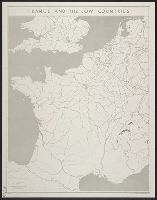
Creator:
Published / Created:
1943
Call Number:
38gma 1943
Container / Volume:
BRBL_00170
Image Count:
1
Resource Type:
Maps, Atlases & Globes
Description:
"No. 683.", Includes inset northern regions., and Includes legend on sheet.
Publisher:
O.S.S.,
Subject (Geographic):
France--Maps
Subject (Topic):
Waterways--France--Maps
Found in:
Beinecke Rare Book and Manuscript Library > France Navigable Waterways [cartographic material].
Creator:
Published / Created:
1944
Call Number:
38gm 1944A
Container / Volume:
BRBL_00170
Image Count:
1
Resource Type:
Maps, Atlases & Globes
Description:
"No. 3352." and Dated: 30 May 1944.
Publisher:
OSS,
Subject (Geographic):
Benelux Countries--Maps and France--Maps
Found in:
Beinecke Rare Book and Manuscript Library > France and the Low Countries [cartographic material] / compiled and drawn in the Branch of Research and Analysis, OSS.
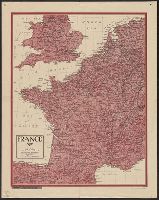
Creator:
Published / Created:
1943
Call Number:
38gme 1943B
Container / Volume:
BRBL_00171
Image Count:
1
Resource Type:
Maps, Atlases & Globes
Description:
"Map no. 2318 (supersedes map no. 641); revised 14 July 1943.", Inset: Paris and environs., and Shows: international boundaries, railways (4 categories).
Publisher:
O.S.S.,
Subject (Geographic):
France--Maps
Subject (Topic):
Railroads--France--Maps
Found in:
Beinecke Rare Book and Manuscript Library > France, national railroads [cartographic material] / compiled and drawn in the Branch of Research and Analysis, OSS.
Published / Created:
1944
Call Number:
38 1944A
Container / Volume:
BRBL_00155
Image Count:
1
Resource Type:
Maps, Atlases & Globes
Description:
"U.S. Government Printing Office: 1944 - 538110".
Publisher:
U.S. Government Printing Office,
Subject (Geographic):
France--Maps
Found in:
Beinecke Rare Book and Manuscript Library > France.
Creator:
Published / Created:
1942
Call Number:
654ed 1942
Container / Volume:
BRBL_00344
Image Count:
1
Resource Type:
Maps, Atlases & Globes
Description:
"Ethnic boundaries highly generalized." and "Map no. 1057."
Publisher:
The Division,
Subject (Topic):
Ethnology--Africa, West--Maps
Found in:
Beinecke Rare Book and Manuscript Library > French West Africa ethnic groups / drawn in the Geography Division, O.S.S.
Creator:
Published / Created:
1921
Call Number:
56fd 1921
Container / Volume:
BRBL_00298
Image Count:
1
Resource Type:
Maps, Atlases & Globes
Description:
"Compiled from China Inland Mission map of the Chinese Empire (1911), Stanford's Map of the Siberian Railway (1919), Imperial Geological Survey map of Japan (1911) ..." and Also shows railways in Japan, Korea, northeastern Vietnam, and Siberia, USSR.
Publisher:
Department of State,
Subject (Geographic):
China--Maps
Subject (Name):
United States. Department of State
Subject (Topic):
Harbors--China--Maps, Railroads--China--Maps, and Railroads--East Asia--Maps
Found in:
Beinecke Rare Book and Manuscript Library > General map of China and adjacent regions showing treaty ports and railroads / prepared for the Department of State by the Topographic Branch, U.S. Geological Survey, 1921.
Creator:
Published / Created:
1912
Call Number:
848 G95 1912
Container / Volume:
BRBL_00632
Image Count:
1
Resource Type:
Maps, Atlases & Globes
Alternative Title:
Geological Survey bulletin. 498. and Headwater region of Gulkana and Susitna Rivers, Alaska
Description:
"Bulletin 498, Plate I.", Relief shown by contours and spot heights., and Surveyed in 1896, 1909, 1910.
Publisher:
Geological Survey,
Subject (Geographic):
Gulkana River Region (Alaska)--Maps and Susitna River Region (Alaska)--Maps
Subject (Name):
Bagley, James Warren, 1881-1947, Brooks, Alfred H. (Alfred Hulse), 1871-1924, Giffin, C. E, and Witherspoon, D. C
Subject (Topic):
Geology--Alaska--Gullkana River Region--Maps and Geology--Alaska--Sustina River Region--Maps
Found in:
Beinecke Rare Book and Manuscript Library > Geologic reconnaissance map of headwater region of Gulkana and Susitna Rivers, Alaska / U.S. Geological Survey. Alfred H. Brooks, geologist in charge of division, topography and triangulation by D.C. Witherspoon, C.E. Giffin and J.W. Bagley.
Creator:
Published / Created:
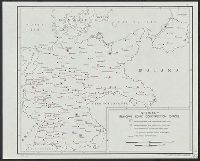
1944
Call Number:
36gmb 1944B
Container / Volume:
BRBL_00130
Image Count:
1
Resource Type:
Maps, Atlases & Globes
Description:
"No. 3167." and Dated: 13 April 1944.
Publisher:
OSS,
Subject (Geographic):
Germany--Maps
Subject (Topic):
Highway departments--Germany--Maps
Found in:
Beinecke Rare Book and Manuscript Library > Germany : principal road construction offices / compiled and drawn in the Branch of Research and Analysis, OSS.
Branch:v1.61.6 ,Deployed:2024-06-12T09:55:36-04:00