Anville, Jean Baptiste Bourguignon d', 1697-1782 Aveline, J. A. Coypel, Charles-Antoine, 1694-1752
Published / Created:
1743
Call Number:
1982 Folio 10
Image Count:
2
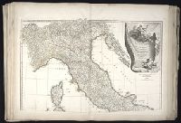
Description:
Also appeared in Anville's [Atlas general. Paris : Jean Baptiste Bourguignon d'Anville, 1771]., Covers also Corsica and Malta., Includes ornamental cartouche drawn and engraved by Coypet and Aveline., No. 17 of 43 maps bound together in composite atlas., Par le Sr. d'Anville ; de la gravure de P. Bourgoin., Relief shown pictorially., and Scale [ca. 1:1,500,000].
Bar scales given in mille pas geometriques, ou milles d'Italie, lieues communes de France, lieues d'une heure de Chemin, lieues communes d'Allemagne, and lieues communes de Suisse., Includes 33 coats of arms., No. 15 of 69 maps bound together in composite atlas., Relief shown pictorially., and Scale [ca. 1:585 000].
Publisher:
Chez H. Iaillot
Subject (Geographic):
Switzerland --Administrative and political divisions --Maps --Early works to 1800 and Switzerland --Maps --Early works to 1800
Cercle de Franconie, ou sont les eveches De Wurtzburg, de Bamberg, et d'Aichstet, les estats du grand Maistre des Chevaliers Teutons, les Marquisats de Cullembach, et d'Ohnspach, les Comtes d'Henneberg, d'Holach, de Reineck, de Wertheim, d'erpach, de Schwartzenberg, et de Castel, les Baronies de Limpurg, et de Sensheim, et les villes imperiales de Nurenberg, de Rotenburg, de Schweinfurt, Windsheim, et de Weissenburg
Description:
Bar scales in Italian miles, common leagues of Germany, great leagues of Germany, common leagues of France, great leagues of France, and leagues of one hours traveling., Dresse sur les Memoires les plus Nouveaux par le Sr. Sanson., Ferro meridian., No. 30 of 69 maps bound together in composite atlas., Relief shown pictorially., and Scale [ca. 1:510 000].