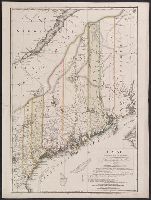
"Zu Ebelings Erdbeschreibung von America.", Also shows county boundaries., Bar scales given in "Geographische Meilen 15 auf einen Grad" and "Englische meilen 69 4/25 auf einen Grad.", Includes index to land grants., Place names in German and Englis, and Watermark.
Publisher:
Bey Carl Ernst Bohn,
Subject (Geographic):
Maine--Administrative and political divisions--Maps--Early works to 1800 and Maine--Maps--Early works to 1800
Subject (Name):
Bohn, Carl Ernst, Ebeling, Christoph Daniel,--1741-1817--Presentation inscription to N. Webster, Ebeling, Christophe Daniel, 1741-1817. Erdbeschreibung und Geschichte von Amerika, and Sander, Wilhelm, 1766-1836, engraver
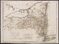
"W. Sander, sculp.", "Zu Ebelings Erdbeschreibung von Amerika.", Bar scales given in "Geographische Meilen oder ein Grad des Aequators" and "Englische meilen 69 4/25 auf einen Grad.", In upper right margin: No. VII., Place names in English and German., Prime meridians: Greenwich and Washington., Relief shown by hachures., Sheet measures 51.5 x 68.9 cm., Shows county and some township boundaries., and Watermark.
Publisher:
Bey Carl Ernst Bohn,
Subject (Geographic):
New York (State)--Administrative and political divisions--Maps--Early works to 1800 and New York (State)--Maps--Early works to 1800
Subject (Name):
Bohn, Carl Ernst, Ebeling, Christoph Daniel,--1741-1817--Presentation inscription to N. Webster, Ebeling, Christophe Daniel, 1741-1817. Erdbeschreibung und Geschichte von Amerika, and Sander, Wilhelm, 1766-1836, engraver