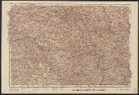
"Mai 1904.", Relief shown by shading and spot heights. Depths shown by soundings and bathymetric contours., and Shows Guandong Peninsula, southern Liaoning Sheng.
Publisher:
Service géographique de l'Armée,
Subject (Geographic):
Dalian Region (China)--Maps and Lüshun Region (China)--Maps
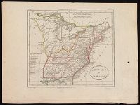
From William Guthrie's Atlas universel (1802)., In upper left corner: Atl. p. 25., In upper right corner: Atl. Un. 34., Prime meridians: Ferro and Paris., and Relief shown pictorially.
Publisher:
[H. Langlois],
Subject (Geographic):
East (U.S.)--Maps--Early works to 1800.
Subject (Name):
Blondeau, active 18th century-19th century and Guthrie, William, 1708-1770. Atlas universel.
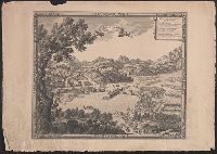
"Corrections essentialles en Juil. 1882.", Includes coordinates of lighthouse and elevation drawing as viewed from the NNE., and Shows fortifications, churches, and lighthouses.
"Guill. Delahaye, sculpsit.", Ornamental cartouche., Relief shown pictorially., Sheet 50.6 x 67.1 cm., and Stamp on verso: 80.
Publisher:
[publisher not identified],
Subject (Geographic):
Prussia (Germany)--Maps--Early works to 1800, Prussia, East (Poland and Russia)--Maps--Early works to 1800, and Prussia, West (Poland)--Maps--Early works to 1800
Subject (Name):
Haye, G. de la and Hughes, Thomas Lowe,--1925---Ownership
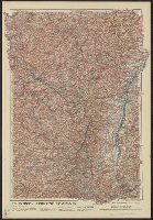
"Front au 1er. Janvier 1916.", "Supplément à l'illustration.", Ms. note outside bottom right margin "L'illus MY'19"., and Shows location of Western Front, railways, roads, canals, borders, and fortifications.
"Front au 1er. Janvier 1916.", "Supplément à l'illustration.", Ms. note outside bottom right margin "L'illus My'19"., and Shows location of Western Front, railways, roads, canals, borders, and fortifications.