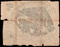
"The figures on the map refer to the pages in the guide where the train services are shewn.", Also shows steamship routes and distances., Includes inset of London region and copyright note., and Metropolitan London cab regulations, list of railroad stations in L
Publisher:
Henry Blacklock & Co. Ltd., Engravers and Lithographers,
Subject (Geographic):
British Isles--Maps
Subject (Topic):
Railroad stations--Great Britain--Maps, Railroads--Great Britain--Maps, Railroads--Ireland--Maps, and Steamboat lines--Great Britain--Maps
[Atlas factice of 96 maps by Blaeu, Visscher, Jansson, Hondius and others]
Image Count:
1
Description:
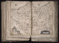
Imperfect: mutilated along fold, with some loss of text; bar scale cut out and replaced in ms. Reinforced along edges with printed waste. Sheet measures 39.1 x 50.4 cm. No. 78 of 92 maps bound together. and Numbered 84 [80, cancelled] on verso.
Publisher:
Excudebat Ioannes Ianssonius
Subject (Geographic):
Brandenburg (Germany : Landkreis) --Maps --Early works to 1800s, Mecklenburg-Vorpommern (Germany) --Maps --Early works to 1800, and Pomerania (Poland and Germany) --Maps --Early works to 1800
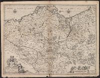
Brandebvrgvm Marchionatvs, cum Ducatibus Pomeraniae et Meklenbvrgi
Description:
Bar scale given in "milliaria Germanica communia"., From Henricus Hondius and Joannes Janssonius's Atlas (English ed.), 1636., Imperfect: mutilated along fold, with some loss of text. Sheet measures 42.4 x 54.2 cm., and In English on verso; with caption title "T
Publisher:
Excudebat Ioannes Ianssonius,
Subject (Geographic):
Brandenburg (Germany : Landkreis)--Maps--Early works to 1800, Mecklenburg-Vorpommern (Germany)--Maps--Early works to 1800, and Pomerania (Poland and Germany)--Maps--Early works to 1800
Subject (Name):
Hondius, Hendrik, 1597-1651. Atlas novus. English and Jansson, Jan, 1588-1664. Atlas novus. English
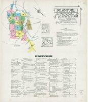
Sanborn fire insurance maps are a rich source of historic data on the urban built environment of North America during the 19th and early 20th centuries. The atlases were created for the purpose of underwriting fire insurance policies, which depended upon accurate and frequently-updated information about construction materials, municipal and transportation infrastructure, industrial and commercial landuse and more. The Yale University Library Map Department scanned its holdings of Sanborn fire insurance maps (consisting primarily of Connecticut towns) in order to make the maps more accessible.
Alternative Title:
Feb. 1924, Branford, Conn.
Description:
"(1469) 24 sheets.", Contains information on prevailing winds, population, water facilities, and fire department., Includes index of streets and specials., Partial cadastral map., and SMLMAPL 766 B72 1924: Sheets disbound.
Subject (Geographic):
Branford (Conn.)--Maps
Subject (Topic):
Fire risk assessment--Connecticut--Branford--Maps and Real property--Connecticut--Branford--Maps
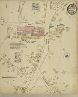
Sanborn fire insurance maps are a rich source of historic data on the urban built environment of North America during the 19th and early 20th centuries. The atlases were created for the purpose of underwriting fire insurance policies, which depended upon accurate and frequently-updated information about construction materials, municipal and transportation infrastructure, industrial and commercial landuse and more. The Yale University Library Map Department scanned its holdings of Sanborn fire insurance maps (consisting primarily of Connecticut towns) in order to make the maps more accessible.
Alternative Title:
July 1884, Branford, Conn.
Description:
"2 sheets.", Contains information on population, water facilities, and fire department., Partial cadastral map., SMLMAPL 766 B72 1884 Copy 1: Cover and stamps of Continental Insurance Co., New York. Sheets backed with linen., and SMLMAPL 766 B72 1884 Copy 2: Sheets disbound. "Triplicate" stamp on both sheets.
Subject (Geographic):
Branford (Conn.)--Maps
Subject (Name):
Continental Insurance Company Ownership
Subject (Topic):
Fire risk assessment--Connecticut--Branford--Maps and Real property--Connecticut--Branford--Maps