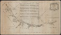
Coastal chart., Imperfect: Mutilated with loss of information., Includes text: "Instructions for the coast of South Carolina, Georgia, and the coast of St. Augustin"., and Oriented with north to the left.
Publisher:
W. Mount and T. Page,
Subject (Geographic):
Atlantic Coast (South Atlantic States)--Maps., Georgia--Maps--Early works to 1800., and South Carolina--Maps--Early works to 1800.
Subject (Topic):
Coastwise navigation--Atlantic Coast (South Atlantic States)
From Jefferys's The American atlas ... London : Printed and sold by R. Sayer and J. Bennett, 1776., Hand col. Sheet measures 55.1 x 73.5 cm. Stamped no. on verso: 12. Cross Collection no. 160., and Relief shown pictorially. Depths shown by soundings.
Publisher:
By Thomas Jefferys, geographer to the King, printed for Robt. Sayer & Jno. Bennett,
Subject (Geographic):
Newfoundland, Island of (N.L.)--Maps--Early works to 1800
Subject (Name):
Cook, James, 1728-1779, Jefferys, Thomas, d. 1771. American atlas, Lane, Michael, fl. 1768-1784, and Robert Sayer and John Bennett (Firm)
Attributed to Defoe by Prof. John R. Moore of Indiana university., Paging irregular: p. 431-441 numbered 417-427., and Up to p. 414 and from the second p. 417 to the end, the book is a reissue of the 2d edition, 1724. Between p. 416 and 417 of the original [?] pages of new matter have been added, mostly made up of chap. XVII. Of Capt. John Gow, alias Smith."
Subject: Map of the central part of the United States showing the middle Atlantic states, and the Ohio River Valley region. Includes anecdotes on the different Indian nations and the lands. Shows dates of settlements and agreements, locations of quarries,
Alternative Title:
Middle British colonies.
Description:
Differs from other copies in extension of the Connecticut River north beyond "Great Falls." Differs also in coloration of boundaries: Ohio River is colored as a boundary: Pennsylvania is shown as extending north to Lake Ontario, etc. and Shows "West longitude
Publisher:
Printed for Carington Bowles,
Subject (Geographic):
Canada--Maps--Early works to 1800, Middle Atlantic States--Maps--Early works to 1800, Northeastern States--Maps--Early works to 1800, and Ohio River Valley--Maps--Early works to 1800
Subject (Name):
Bowles, Carington, 1724-1793, publisher
Subject (Topic):
British--America--Maps--Early works to 1800 and Chron.--1771
"The seat of the war in the middle British colonies, containing Virginia, Maryland, the Delaware counties, &ca.", From the author's The American military pocket atlas. [1776], Hand colored., Inset: A sketch of the upper parts of Canada., and Relief shown pictoria
Publisher:
Printed for R. Sayer & J. Bennett, map, chart & printsellers,