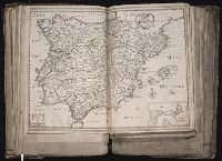
[Atlas factice of 96 maps by Blaeu, Visscher, Jansson, Hondius and others]
Image Count:
1
Description:
Imperfect: wormhole in center crease, with no loss of text. Reinforced along lower edges with manuscript waste. Sheet measures 38.9 x 51.5 cm. No. 33 of 92 maps bound together.
Carte détaillée de l'Afrique et des îles qui en dependent and Afrique méridionale
Description:
BEIN 60 1828: Blindstamps: G.H. Picouet a Paris. Manuscript annotations on both sheets., Relief shown by hachures., Northern sheet has "Atlas en 65 feuilles, No. 52" above neat line; southern sheet "Atlas en 65 feuilles, No. 53.", and Includes insets: Extrémité Sud de l'Afrique, ou Colonie du Cap, Pays des Hottentots et Betjouanas; Archipel du Nord-Est de Madagascar; Abyssinie et Pays des Gallas, etc.
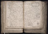
[Atlas factice of 96 maps by Blaeu, Visscher, Jansson, Hondius and others]
Image Count:
1
Description:
Imperfect: wormed in middle crease, with some loss of text. Reinforced along lower edges with manuscript waste. Sheet measures 39 x 51.5 cm. No. 36 of 92 maps bound together.
[Atlas factice of 96 maps by Blaeu, Visscher, Jansson, Hondius and others]
Image Count:
1
Description:
Imperfect: tear in upper left corner, repaired with no loss of text. Reinforced along lower edges with manuscript waste. Sheet measures 38.2 x 51.5 cm. No. 35 of 92 maps bound together.
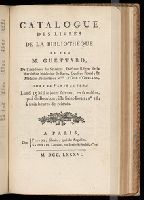
Publisher:
Christophe Tassin
Subject (Geographic):
Artois (France) --Maps --Early works to 1800 and Picardy (France) --Maps --Early works to 1800
BEIN 2000 628: With: Catalogue des livres rares et précieux de M. ***. A Paris : Chez. G. de Bure ..., 1780; Ms. pricing and annotations throughout; imperfect: fore edge mutilated on several pages, obscuring ms. annotations. No. 2 of 2 titles bound together. and Publishers' names enclosed in bracket on t.p.