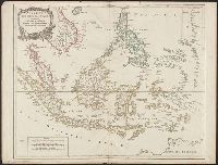
Covers present-day Indonesia, the Philippines, Malayan peninsula, Indo-Chinese peninsula, and north-west coast of Australia., From: Atlas universel / par m. Robert geographe et Robert de Vaugondy son fils. Paris, 1757-[1786]., Includes inset map., and Inset: Isl
Publisher:
[publisher not identified],
Subject (Geographic):
Asia--East Indies, Australia--Maps--Early works to 1800., East Indies--Maps--Early works to 1800., Mariana Islands--Maps--Early works to 1800., and Southeast Asia--Maps--Early works to 1800.
Subject (Name):
Haye, G. de la, engraver. and Robert de Vaugondy, Gilles, 1688-1766. Atlas universel.
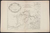
Anville, Jean Baptiste Bourguignon d', 1697-1782, cartographer
Published / Created:
Novembre MDCCLV [1755]
Call Number:
71 1755T
Container / Volume:
BRBL_00364
Image Count:
3
Resource Type:
Maps, Atlases & Globes
Description:
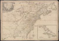
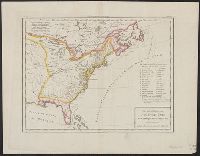
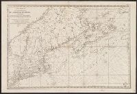
"Sous le privilége de l'Academie.", From Anville's Atlas général., Includes 5 bar scales., Prime meridian: Ferro., Relief shown pictorially., and Watermarks.
Publisher:
Chez l'auteur, aux galeries du Louvre, ‡c Novembre MDCCLV [1755]
Subject (Geographic):
Canada--Maps--Early works to 1800, Louisiana--Maps--Early works to 1800, and North America--Maps--Early works to 1800
Subject (Name):
Anville, Jean Baptiste Bourguignon d', 1697-1782. Atlas général and Haye, G. de la, engraver