Skip to search
Skip to main content
Skip to first result
Search
You Searched For
Genre
Hand coloring
Genre
Maps
New Search
Search Results
Creator:
Published / Created:
[ca. 1762]
Call Number:
2003 Folio 85
Image Count:
1
Description:
BEIN 2003 Folio 85: No. 31 of 45 maps bound together with binder's spine title: Atlas of America; ms. table of contents. Bookplate: Robinson. Bookplate of Paul Mellon., Hand colored., Includes inset A general plan of Port Royal, in which the different states of the town are accurately laid down, ca. 1:3,200., Relief shown pictorially. Soundings shown in fathoms., Scale [ca. 1:420,000]., and the greatest part drawn or corrected from actual surveys made by Mr. Sheffield and others.
Publisher:
Printed for John Bowles ... and Carington Bowles
Subject (Geographic):
Jamaica -- Maps -- Early works to 1800 and Port Royal (Jamaica) -- Maps -- Early works to 1800
Found in:
Beinecke Rare Book and Manuscript Library > A new map of Jamaica: in which the several towns, forts, & settlements are accurately laid down, as well as the situations & depths of the most noted harbours and anchoring places
Published / Created:
1833
Call Number:
2002 Folio 97
Collection Title:
Tanner’s universal atlas : subscription price $1.00 a number, seperate [sic] numbers $1.50 each
Image Count:
1
Resource Type:
Maps, Atlases & Globes
Alternative Title:
II.-Map of the state of Maine
Description:
Plate identified as "II" on atlas cover and "5" on map. and Verso blank.
Subject (Geographic):
Maine
Collection Created:
Philadelphia : Published by the author, 1833-1836
Found in:
Beinecke Rare Book and Manuscript Library > A new map of Maine
Published / Created:
1833
Call Number:
1976 Folio 98
Collection Title:
A new universal atlas, containing maps of the various empires, kingdoms, states and republics of
Image Count:
1
Resource Type:
Maps, Atlases & Globes
Subject (Geographic):
Maine
Collection Created:
Philadelphia, Published by the author, 1836
Found in:
Beinecke Rare Book and Manuscript Library > A new map of Maine
Published / Created:
1850
Call Number:
1976 Folio 96
Collection Title:
A new universal atlas containing maps of the various empires, kingdoms, states and republics of the
Image Count:
1
Resource Type:
Maps, Atlases & Globes
Publisher:
Thomas, Cowperthwait & Co
Subject (Geographic):
Maine
Collection Created:
Philadelphia, Cowperthwait, DeSilver & Butler, 1854, c1850
Found in:
Beinecke Rare Book and Manuscript Library > A new map of Maine
Call Number:
1976 Folio 94
Collection Title:
A new universal atlas containing maps of the various empires, kingdoms, states and republics of the
Image Count:
1
Resource Type:
Maps, Atlases & Globes
Subject (Geographic):
Maine
Collection Created:
Philadelphia, S.A. Mitchell, 1849
Found in:
Beinecke Rare Book and Manuscript Library > A new map of Maine
Call Number:
1976 1233
Collection Title:
Forty-two new maps of Asia, Africa, and America ... : all engrav’d, according to the latest
Image Count:
1
Alternative Title:
Newfoundland, New Scotland, &c
Description:
In pencil on verso: 38. and Table of contents for maps 2-20 in section "America" misnumbered.
Subject (Geographic):
New Brunswick --Maps, Newfoundland --Maps --Early works to 1800, and Nova Scotia --Maps --Early works to 1800
Subject (Name):
Nicholson, John, d. ca. 1717, bookseller
Subject (Topic):
Atlases --Early works to 1800
Collection Created:
London : Printed for J. Nicholson ..., 1716 ...
Found in:
Beinecke Rare Book and Manuscript Library > A new map of Newfound land, New Scotland the isles of Breton, Anticoste, St, Iohns &c. together with the fishing bancks
Call Number:
1976 1233
Collection Title:
Forty-two new maps of Asia, Africa, and America ... : all engrav’d, according to the latest
Image Count:
1
Alternative Title:
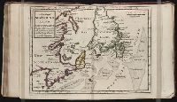
North America
Description:
In pencil on verso: 34. and Table of contents for maps 2-20 in section "America" misnumbered.
Subject (Geographic):
North America --Maps --Early works to 1800
Subject (Name):
Nicholson, John, d. ca. 1717, bookseller
Subject (Topic):
Atlases --Early works to 1800
Collection Created:
London : Printed for J. Nicholson ..., 1716 ...
Found in:
Beinecke Rare Book and Manuscript Library > A new map of North America according to the newest observations
Creator:
Published / Created:
1755
Call Number:
2003 Folio 85
Image Count:
1
Description:
BEIN 2003 Folio 85: No. 14 of 45 maps bound together with binder's spine title: Atlas of America; ms. table of contents. Bookplate: Robinson. Bookplate of Paul Mellon., Hand colored., Includes table of sources of observations., Relief shown pictorially. Depths shown by soundings., Scale [ca. 1:2,600,000]., Scale ca. 1:1,900,000;English marine leagues 20 to a degree; English miles 69 1/2 to a degree., and Shows Maritime Provinces, New England, and St. Lawrence Valley region to Montreal.
Publisher:
Thos. Jefferys
Subject (Geographic):
Canada -- Maps -- Early works to 1800, Maritime Provinces -- Maps -- Early works to 1800, New England -- Maps -- Early works to 1800, Nova Scotia -- Maps -- Early works to 1800, and Saint Lawrence River Valley -- Maps -- Early works to 1800
Found in:
Beinecke Rare Book and Manuscript Library > A new map of Nova Scotia, and Cape Britain: With the adjacent parts of New England and Canada, composed from a great number of actual surveys; and other materials regulated by many new astronomical observations of the longitude as well as latitude; with a
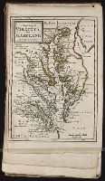
Call Number:
1976 1233
Collection Title:
Forty-two new maps of Asia, Africa, and America ... : all engrav’d, according to the latest
Image Count:
1
Alternative Title:
Virginia and Maryland
Description:
In pencil on verso: 41. and Table of contents for maps 2-20 in section "America" misnumbered.
Subject (Geographic):
Maryland --Maps --Early works to 1800 and Virginia --Maps --Early works to 1800
Subject (Name):
Nicholson, John, d. ca. 1717, bookseller
Subject (Topic):
Atlases --Early works to 1800
Collection Created:
London : Printed for J. Nicholson ..., 1716 ...
Found in:
Beinecke Rare Book and Manuscript Library > A new map of Virginia, and Maryland
Branch:v1.61.6 ,Deployed:2024-06-12T09:55:36-04:00