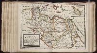
British & Spanish territories according to the treaty of 1784
Description:
For a description of the second and third states see Stevens and Tree, Comparative Cartography, Map Collectors' Circle (1967)., Includes historical notes and a color key., Includes text., No. 40 of 43 maps bound together in composite atlas., Prime meridian: London., Relief shown pictorially., Scale [ca. 1:6,750,000]., and Shows numerous boundary changes.
Publisher:
Willm. Faden
Subject (Geographic):
United States --Boundaries --Maps --Early works to 1800 and United States --Maps --Early works to 1800
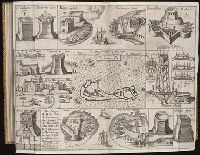
Twenty four new and accurate maps of the several parts of Europe ... : all (except the last) new
Image Count:
1
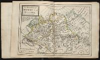
Alternative Title:
Muscovy, or Russia
Description:
In pencil on verso: 5.
Subject (Geographic):
Russia --Maps --Early works to 1800
Subject (Name):
Barker, B. (Benjamin), d. 1764, bookseller, Clements, Henry, d. 1719, bookseller, King, Charles, d. 1735, bookseller, Nicholson, John, d. ca. 1717, bookseller, Parker, Richard, fl. 1692-1725, bookseller, and Tooke, Benjamin, d. 1716, bookseller
Subject (Topic):
Atlases --Early works to 1800
Collection Created:
[London] : Sold by J. Nicholson at the King’s-Arms in Little Britain, Benj. Barker and Charles King ..., Benj. Tooke ..., Hen. Clements ..., R. Parker and Ralph Smith under the Royal-Exchange ..., [1715?]
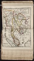
Forty-two new maps of Asia, Africa, and America ... : all engrav’d, according to the latest
Image Count:
1
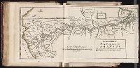
Alternative Title:
The great river Mazanon, or of the Amazons
Description:
In pencil on verso: 31., Right edge of map curled., and Table of contents for maps 2-20 in section "America" misnumbered.
Subject (Geographic):
Amazon River --Maps, Amazon River Region --Maps, Amazon River Valley --Maps, Colombia --Maps --Early works to 1800, Ecuador --Maps --Early works to 1800, and Venezuela --Maps