Skip to search
Skip to main content
Skip to first result
Search
You Searched For
Extent of Digitization
Unspecified
Genre
Maps
New Search
Search Results
Call Number:
Ck44 23
Collection Title:
Kort beskrifning om provincien Nya Swerige uti America : som nu foertjden af the Engelske kallas
Image Count:
1
Description:
Between p. 52 & p. 53., Engraved by Holm, Thomas Campanius, ca. 1670-1702., and Teaching resource: Professor John Mack Faragher, History 141: The American West.
Subject (Geographic):
New England --Maps --Early works to 1800, United States --Maps --Early works to 1800, and Virginia --Maps --Early works to 1800
Collection Created:
Stockholm : Tryckt uti Kongl. boktr. hos S. Wankijfs ankia, med egen bekostnad, af J. H. Werner, 1702
Found in:
Beinecke Rare Book and Manuscript Library > Virginiae N. Angliae N. Hollandiae nec non Nova Sueviae delineatio
Published / Created:
undated
Call Number:
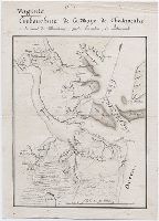
GEN MSS 499
Collection Title:
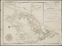
Henri Crublier d'Opterre journal and maps, [1776]-1783
Container / Volume:
Bsd folder 16
Image Count:
1
Subject (Geographic):
America--Maps--Early works to 1800 and United States--History--Revolution, 1775-1783--Maps--Early works to 1800.
Found in:
Beinecke Rare Book and Manuscript Library > Virginie. Embouchure de la Baye de Chesapeake
Creator:
Published / Created:
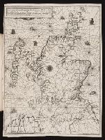
1583
Call Number:
Taylor 163
Collection Title:
La nauigation du roy dEscosse Iaques Cinquiesme du nom, autour de son royaume, & isles Hebrides
Image Count:
1
Alternative Title:
Vraye & exacte description hydrographique des costes maritim
Description:
Bound in following leaf 6.
Subject (Geographic):
Scotland--Description and travel--Early works to 1800
Subject (Topic):
Navigation--Early works to 1800
Collection Created:
A Paris : Chez Gilles Beys, rue S. Iaques au Lis Blanc,
Found in:
Beinecke Rare Book and Manuscript Library > Vraye & exacte description hydrographique des costes maritimes dEscosse & des Isles Orchades Hebrides avec partie dAngleterre & dIrelande feruant a la naiguation [sic] / par N. de Nicolay. 1583.
Creator:
Published / Created:
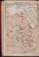
1914
Call Number:
DK16 B3
Collection Title:
Russia with Teheran, Port Arthur, and Peking : handbook for travellers / by Karl Baedeker ; with 40
Image Count:
1
Publisher:
Charles Scribner's Sons
Collection Created:
Leipzig : K. Baedeker ; New York : Charles Scribner's Sons, 1914
Found in:
Beinecke Rare Book and Manuscript Library > Warszawa II (Warsaw.)
Creator:
Call Number:
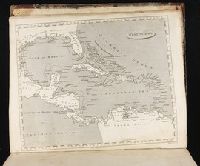
1974 +231
Collection Title:
A new and elegant general atlas, comprising all the new discoveries, to the present time
Image Count:
1
Description:
Map 60 from table of contents.
Subject (Geographic):
Central America--Maps, Cuba--Maps, Mexico--Maps, North America--Maps, Spain--Territories and possessions--Maps, and West Indies--Maps
Collection Created:
Philadelphia, J. Conrad & co., Baltimore, M. & J. Conrad & co. [etc., etc.] 1804
Found in:
Beinecke Rare Book and Manuscript Library > West Indies
Creator:
Published / Created:
1795
Call Number:
GA405 +W44 (LC)
Collection Title:
Mapping the transmississippi West, 1540-1861
Image Count:
1
Description:
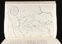
Bound in between p. 158-159. and Map 235a from table of contents.
Subject (Geographic):
Mississippi River Valley--Maps, Missouri River Valley--Maps, North America--Maps, and West (U.S.)--Maps
Collection Created:
San Francisco, Institute of Historical Cartography, 1957-63
Found in:
Beinecke Rare Book and Manuscript Library > Ydea Topografica de los Altos del Missisipi y del Missouri ...
Published / Created:
1781
Call Number:
GEN MSS 499
Collection Title:
Henri Crublier d'Opterre journal and maps, [1776]-1783
Container / Volume:
Bsd folder 16
Image Count:
1
Subject (Geographic):
America--Maps--Early works to 1800 and United States--History--Revolution, 1775-1783--Maps--Early works to 1800.
Found in:
Beinecke Rare Book and Manuscript Library > York en Virginie
Call Number:
Zc20 802crc
Collection Title:
The navigator; or, The traders' useful guide in navigating the Monongahela, Allegheny, Ohio, and
Image Count:
1
Description:
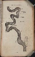
P. 55.
Subject (Geographic):
Chickasaw Bluffs (Tenn.), Mississippi River --Description and travel, Mississippi River --Maps, Mississippi River --Navigation, and Tennessee
Collection Created:
Pittsburgh, From the Press of Zadok Cramer, 1806
Found in:
Beinecke Rare Book and Manuscript Library > [A portion of the Mississippi River, including Chickasaw Bluffs]
Call Number:
Zc20 802crc
Collection Title:
The navigator; or, The traders' useful guide in navigating the Monongahela, Allegheny, Ohio, and
Image Count:
1
Description:
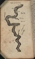
P. 72.
Subject (Geographic):
Mississippi, Mississippi River --Description and travel, Mississippi River --Maps, Mississippi River --Navigation, and Natchez (Miss.)
Collection Created:
Pittsburgh, From the Press of Zadok Cramer, 1806
Found in:
Beinecke Rare Book and Manuscript Library > [A portion of the Mississippi River, including Natchez]
Published / Created:
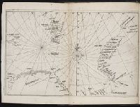
[Ca. 1612]
Call Number:
Taylor 258
Collection Title:
Descriptio ac delineatio geographica detectionis freti, sive, transitus ad occasum supra terras
Image Count:
1
Description:
Bound in after p. [40]., Map has water stain on recto in upper right corner., Printed on recto in lower right corner: F., and Scale [ca. 1:10,000,000].
Subject (Geographic):
Barents Sea --Maps --Early works to 1800. and Norwegian Sea --Maps --Early works to 1800
Collection Created:
Amsterodami Ex officina Hesse lij Gerardi. Anno 1613
Found in:
Beinecke Rare Book and Manuscript Library > [Barents Sea and Norwegian Sea]
Branch:v1.61.6 ,Deployed:2024-06-12T09:55:36-04:00