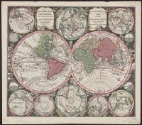
Appeared in author's Atlas novus ... [1742 or later]., Ms. note on verso: Globus terrestris III. Cross collection no. 36., Scale measured at center of hemisphere., Showing two principal terrestrial hemispheres and eight subsidiary hemispheres on various projections; four smaller astronomical diagrams., and Shows California as an island.
Cross Collection no. 245., Imperfect: map of Jamaica cut-out. Two maps (Antigua and Barbados)., Includes explanatory notes and index., Relief shown pictorially., Scales in millaria Anglica communia and/or millaria Anglica statuta., and Sheet title in Latin and German. Individual map titles and text in German. Maps in English and German.
Publisher:
Homann Erben,
Subject (Geographic):
Antigua--Maps--Early works to 1800, B, Barbados--Maps--Early works to 1800, Jamaica--Maps--Early works to 1800, Saint Kitts and Nevis--Maps--Early works to 1800, and West Indies--Maps--Early works to 1800
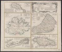
Cross Collection no. 253., Includes explanatory notes and index., Ms. notes in upper right corner., Relief shown pictorially., Scales in millaria Anglica communia and/or millaria Anglica statuta., Sheet title in Latin and German. Individual map titles and text in German. Maps in English and German., and Three maps (Antigua, Barbados, Jamaica). Mounted on linen.
Publisher:
Homann Erben,
Subject (Geographic):
Antigua--Maps--Early works to 1800, Barbados--Maps--Early works to 1800, Bermuda Islands--Maps--Early works to 1800, Jamaica--Maps--Early works to 1800, and Saint Kitts and Nevis--Maps--Early works to 1800
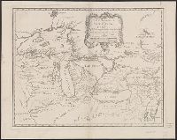
Appeared in Sanson's Cartes générales de toutes les parties du monde (1665)., Includes three bar scales., Prime meridian: Ferro., Relief shown pictorially., Sheet measures 45.2 x 61.6 cm. Ms. note on verso., and Watermark.
Publisher:
Chez Pierre Mariette, rue St. Iacques a l'Esperance, avecq privilege pour vingt ans,
Subject (Geographic):
France--Maps--Early works to 1800
Subject (Name):
Mariette, Pierre, 1634-1716 and Sanson, Nicolas, 1600-1667. Cartes générales de toutes les parties du monde
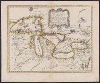
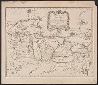
Covers the area from Lake Superior to Kaskaskia and from Delaware Bay to the Mississippi River., Relief shown pictorially., Shows a few towns, missions, forts, Indian villages and tribal territory, rivers and lakes, portages, and early place-names., and Watermark.
Publisher:
[Homann Erben?],
Subject (Geographic):
Canada--Maps--Early works to 1800, Great Lakes Region (North America)--Maps--Early works to 1800, and New France--Maps--Early works to 1800
Subject (Name):
Brown, Horace--Stamp, Homann Erben (Firm), and Thorne Collection of Cartogaphy and Geography Stamp
Copy 1: Borders of lakes and frame of map colored in yellow. Backed with linen. Stamp: Thorne Collection of Cartography and Geography. Stamp: Karpinski-von Wieser Map Collection., Covers the area from Lake Superior to Kaskaskia and from Delaware Bay to the Mississippi River., Relief shown pictorially., Shows a few towns, missions, forts, Indian villages and tribal territory, rivers and lakes, portages, and early place-names., and Watermark.
Publisher:
[Homann Erben?],
Subject (Geographic):
Canada--Maps--Early works to 1800, Great Lakes Region (North America)--Maps--Early works to 1800, and New France--Maps--Early works to 1800
Subject (Name):
Homann Erben (Firm) and Thorne Collection of Cartogaphy and Geography Stamp
Copy 2: Stamp: Yale Horace Brown 1900S. Manuscript note in unidentified hand., Covers the area from Lake Superior to Kaskaskia and from Delaware Bay to the Mississippi River., Relief shown pictorially., and Shows a few towns, missions, forts, Indian villages and tribal territory, rivers and lakes, portages, and early place-names.
Publisher:
[Homann Erben?],
Subject (Geographic):
Canada--Maps--Early works to 1800, Great Lakes Region (North America)--Maps--Early works to 1800, and New France--Maps--Early works to 1800