Skip to search
Skip to main content
Skip to first result
Search
You Searched For
Date
Unknown
Extent of Digitization
Completely digitized
Genre
Maps
Date Created
[Missing]
New Search
Search Results
Call Number:
777 C425 1799
Container / Volume:
BRBL_00503
Image Count:
1
Resource Type:
Maps, Atlases & Globes
Description:
Allardice sc. and Inset: Plan of the town of Havre de Grace.
Subject (Geographic):
Chesapeake Bay (Md. and Va.)--Maps--Early works to 1800
Found in:
Beinecke Rare Book and Manuscript Library > A map of the head of the Chesapeake Bay and Susquehanna River shewing the navigation of the same with a topographical description of the surrounding country from an actual survey by C.P. Hauducoeur 1799.
Call Number:
783 1775
Container / Volume:
BRBL_00507
Image Count:
3
Resource Type:
Maps, Atlases & Globes
Description:
Drawn by Joshua Fry & Peter Jefferson 1775. and Pos. photostat and negative.
Publisher:
Thos Jefferys & Robt. Sayer.
Subject (Geographic):
Virginia--Maps--Early works to 1800
Found in:
Beinecke Rare Book and Manuscript Library > A map of the most inhabited part of Virginia part of Pensilvania, new Yersey & North Carolina.
Call Number:
735 1790
Container / Volume:
BRBL_00689
Image Count:
1
Resource Type:
Maps, Atlases & Globes
Alternative Title:
Map showing the communication of the lakes and the rivers between Lake Superior and Slave Lake in North America
Description:
"Gent. Mag. March 1790, Pl. I, p. 197" in upper right hand corner., Mounted on linen. Sheet measures 20.7 x 24.3 cm. Cross Collection no. 178., Prime meridian: London., and Relief shown by hachures.
Publisher:
s.n., 1790?]
Subject (Geographic):
Canada--Maps--Early works to 1800 and North America--Maps--Early works to 1800
Found in:
Beinecke Rare Book and Manuscript Library > A map shewing the communication of the lakes and the rivers between Lake Superior and Slave Lake in North America.
Creator:
Call Number:
623 1750
Container / Volume:
BRBL_00333
Image Count:
1
Resource Type:
Maps, Atlases & Globes
Alternative Title:
Nubia & Abissinia
Description:
From Bowen's A complete system of geography, 1747., Includes text and ill., and Relief shown pictorially.
Publisher:
Printed for W. Innys, R. Ware [etc.], 1747]
Subject (Geographic):
Africa, Eastern--Maps--Early works to 1800 and Africa, North--Maps--Early works to 1800
Subject (Name):
Bowen, Emanuel, d. 1767. Complete system of geography
Found in:
Beinecke Rare Book and Manuscript Library > A new and accurate map of Nubia & Abissinia, together with all the kingdoms tributary thereto, and bordering upon them / laid down from the latest & best authorities and regulated by astronl. observations ny Emanl. Bowen.
Creator:
Call Number:
304 1712
Container / Volume:
BRBL_00033
Image Count:
1
Resource Type:
Maps, Atlases & Globes
Alternative Title:
General Diet of the Empire, or its Parliament.
Description:
Inset illustration of the Reichstag of Holy Roman Empire, with title: The General Diet of the Empire, or it's Parliament.
Subject (Geographic):
Europe, Central--Maps--Early works to 1800, Germany--Maps--Early works to 1800, Hungary--Maps--Early works to 1800, Romania--Maps--Early works to 1800, and Switzerland--Maps--Early works to 1800
Subject (Name):
Holy Roman Empire.--Reichstag and Hughes, Thomas Lowe,--1925---Ownership
Found in:
Beinecke Rare Book and Manuscript Library > A new map of Germany, Hungary, Transilvania & the Suisse cantons : with many remarks not extant in any map : according to ye newest and most exact observations / by Herman Moll, geographer.
Creator:
Call Number:
401 1811
Container / Volume:
BRBL_00233
Image Count:
1
Resource Type:
Maps, Atlases & Globes
Description:
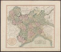
Hand colored. Stamp: Karpinski-von Wieser Map Collection. Label: 17., Meridian: Greenwich., and Relief shown by hachures.
Subject (Geographic):
Genoa (Italy : Province)--Maps, Milan (Italy : Province)--Maps, Piedmont (Italy)--Maps, and Savoy (France and Italy)--Maps
Found in:
Beinecke Rare Book and Manuscript Library > A new map of Piedmont, the duchies of Savoy and Milan, and the republic of Genoa, with their subdivisions : from the latest authorities / by John Cary.
Creator:
Call Number:
39 1801
Container / Volume:
BRBL_00186
Image Count:
1
Resource Type:
Maps, Atlases & Globes
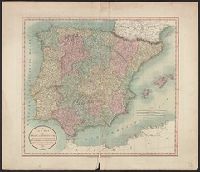
Description:
Appeared in Cary's new universal atlas, London, 1808. and Relief shown pictorially.
Subject (Geographic):
Portugal--Maps and Spain--Maps
Subject (Name):
Cary, John, ca. 1754-1835. Cary's new universal atlas and Hughes, Thomas Lowe,--1925---Ownership
Found in:
Beinecke Rare Book and Manuscript Library > A new map of Spain and Portugal : divided into their respective kingdoms and provinces from the latest authorities / by John Cary, engraver.
Creator:
Call Number:
3614 1799
Container / Volume:
BRBL_00135
Image Count:
1
Resource Type:
Maps, Atlases & Globes
Description:
Appeared in Cary's New universal atlas, London, 1808., Covers East Prussia., and Printed on verso: 36.
Subject (Geographic):
Prussia, East (Poland and Russia)--Maps--Early works to 1800
Subject (Name):
Cary, John, approximately 1754-1835. Cary's new universal atlas and Hughes, Thomas Lowe,--1925---Ownership
Found in:
Beinecke Rare Book and Manuscript Library > A new map of the Kingdom of Prussia : with its divisions into provinces and governments ; from the latest authorities / by John Cary, engraver, 1799.
Creator:
Call Number:
32 L84 1766
Container / Volume:
BRBL_00048
Image Count:
1
Resource Type:
Maps, Atlases & Globes
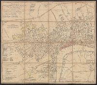
Subject (Geographic):
London (England)--Maps--Early works to 1800 and Westminster (London, England)--Maps--Early works to 1800
Found in:
Beinecke Rare Book and Manuscript Library > A new plan of the city and liberty of Westminster ... / drawn & engraved by Thomas Jefferys ...
Published / Created:
Undated
Call Number:
1973 Folio 10
Image Count:
1
Resource Type:
Maps, Atlases & Globes
Description:
Additional map not listed on manuscript contents page.
Subject (Geographic):
Rhine River
Found in:
Beinecke Rare Book and Manuscript Library > A view of Prince Charles's passage over ye Rhine being a new and correct plan of that river from ye city of Maintz to Fort Louis
Branch:v1.61.8 ,Deployed:2024-06-20T11:15:15-04:00