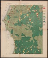
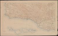
Port Orford quadrangle, Oregon, land classification and density of standing timber.
Description:
"Julius Bien & Co. Lith. N.Y.", "Surveyed in 1897-98.", Plate CXXVI from the "Twenty-first annual report" of the U.S. Geological Survey, Part 5, Forest reserves (1900)., Relief shown by contours and spot heights., and Shows seven classes of land cover.
Publisher:
The Survey,
Subject (Geographic):
Coos County (Or.)--Maps and Curry County (Or.)--Maps
Subject (Name):
Geological Survey (U.S.). Annual report, Johnson, A. J, and Murlin, A. E
Subject (Topic):
Forests and forestry--Oregon--Coos County--Maps, Forests and forestry--Oregon--Curry County--Maps, Land capability for agriculture--Oregon--Coos County--Maps, and Land capability for agriculture--Oregon--Curry County--Maps
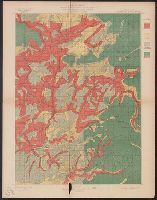
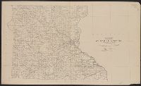
Roseburg quadrangle, Oregon, land classification and density of standing timber.
Description:
"Julius Bien & Co. Lith. N.Y.", "Surveyed in 1894-95.", Plate CXXVIII from the "Twenty-first annual report" of the U.S. Geological Survey, Part 5, Forest reserves (1900)., Relief shown by contours and spot heights., and Shows four classes of land cover.
Publisher:
The Survey,
Subject (Geographic):
Douglas County (Or.)--Maps
Subject (Name):
Barnard, E. C. (Edward Chester), 1863-1921, Geological Survey (U.S.). Annual report, and Johnson, A. J
Subject (Topic):
Forests and forestry--Oregon--Douglas County--Maps and Land capability for agriculture--Oregon--Douglas County--Maps
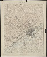
"Henry Gannett, Chief Topographer. H.M. Wilson, Chief Geographer in charge. Triangulation by ... and S.S. Gannett. Topography by Geol. Survey of New Jersey, City of Philadelphia, Frank Sutton ... and Robert Muldrow.", "Surveyed in 1894.", and Relief shown by contours and spot heights.
Publisher:
U.S. Geological Survey,
Subject (Geographic):
Philadelphia Metropolitan Area (Pa.)--Maps
Subject (Name):
Gannett, Henry, 1846-1914, Gannett, Samuel S. (Sameul Stinson), 1861-1939, Geological Survey of New Jersey, Muldrow, Robert, Sutton, Frank, and Wilson, Herbert M. (Herbert Michael), 1860-1920
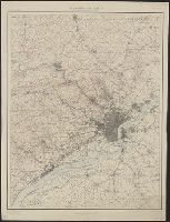
Imperfect: only "Sheet No. 3", sheets 1 and 2 wanting., Relief shown by contours and spot heights., Sheets issued in various editions and reprints., and Text and ill. on verso.
States of Massachusetts, Rhode Island and Connecticut
Description:
"1919.", "Advance sheet. Subject to correction.", Includes index of power stations., and Shows power plants and transmission lines.
Publisher:
U.S. Geological Survey,
Subject (Name):
Thomas, G. D
Subject (Topic):
Electric lines--Connecticut--Maps, Electric lines--Massachusetts--Maps, Electric lines--Rhode Island--Maps, Electric power transmission--Connecticut--Maps, Electric power transmission--Massachusetts--Maps, Electric power transmission--Rhode Island--Maps, Power-plants--Connecticut--Maps, Power-plants--Massachusetts--Maps, and Power-plants--Rhode Island--Maps