Skip to search
Skip to main content
Skip to first result
Search
You Searched For
Genre
Maps
Subject (Name)
Geological Survey (U.S.)
Publication Place
[Washington, D.C.] :
New Search
Search Results
Creator:
Published / Created:
1915
Call Number:
75gce 1915
Container / Volume:
BRBL_00410
Image Count:
1
Resource Type:
Maps, Atlases & Globes
Alternative Title:
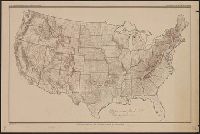
Outline map of the United States by counties
Description:
"Jan. 1, 1915" in lower left margin., Irrigated areas shown on outline map of the United States. Explanation in margin., and This edition has county names printed in blue.
Publisher:
Office of Farm Management,
Subject (Geographic):
United States--Administrative and political divisions--Maps and United States--Maps
Subject (Name):
Geological Survey (U.S.)
Subject (Topic):
Irrigation--United States--Maps
Found in:
Beinecke Rare Book and Manuscript Library > Irrigation map of the United States / engraved and printed by the U.S. Geological Survey ; outline of irrigated areas based upon data collected by the Bureau of the Census, 1910 ; revised by Irrigation Division, Office of Experimental Stations, and by the
Creator:
Published / Created:
1899
Call Number:
80 1899
Container / Volume:
BRBL_00536
Image Count:
1
Resource Type:
Maps, Atlases & Globes
Alternative Title:
Bulletin of the United States Geological Survey.
Description:
Contour interval 250 feet. and In top margin: U.S. Geological Survey, Bulletin No. 190, pl 1.
Publisher:
U.S. Geological Survey,
Subject (Geographic):
Indian Territory--Maps, Topographic, New Mexico--Maps, Topographic, Oklahoma--Maps, Topographic, and Texas--Maps, Topographic
Subject (Name):
Geological Survey (U.S.), Hill, Robert Thomas, 1858-1941, and Johnson, Willard D
Found in:
Beinecke Rare Book and Manuscript Library > Map of Texas and parts of adjoining territories / compiled by and under the direction of Robert T. Hill ; drawn by Henry S. Selden and Willard D. Johnson.
Creator:
Published / Created:
1921
Call Number:
774gbc 1921
Container / Volume:
BRBL_00501A
Image Count:
1
Resource Type:
Maps, Atlases & Globes
Description:
Shows oil refineries and pipelines.
Publisher:
U.S. Geological Survey,
Subject (Geographic):
Pennsylvania--Maps
Subject (Name):
Geological Survey (U.S.)
Subject (Topic):
Gas fields--Pennsylvania--Maps, Oil fields--Pennsylvania--Maps, Petroleum pipelines--Pennsylvania--Maps, and Petroleum refineries--Pennsylvania--Maps
Found in:
Beinecke Rare Book and Manuscript Library > Oil and gas fields of Pennsylvania / compiled under the direction of G.B. Richardson.
Creator:
Published / Created:
1910
Call Number:
75fb 1910
Container / Volume:
BRBL_00410
Image Count:
1
Resource Type:
Maps, Atlases & Globes
Description:
"April 15, 1910.", County names not given., and Handwritten note: "Experimental proof sheets not for publication."
Publisher:
The Division,
Subject (Geographic):
United States--Administrative and political divisions--Maps and United States--Maps
Subject (Name):
Geological Survey (U.S.)
Found in:
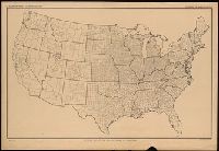
Beinecke Rare Book and Manuscript Library > Outline map of the United States by counties / engraved and printed by the U.S. Geological Survey.
Creator:
Published / Created:
1915
Call Number:
75eb 1910B
Container / Volume:
BRBL_00410
Image Count:
1
Resource Type:
Maps, Atlases & Globes
Description:
"Jan. 1, 1915.", County names printed in turquoise., and SMLMAP 75eb 1910. Ms. figures showing density of population by counties, 1910.
Publisher:
The Division,
Subject (Geographic):
United States--Administrative and political divisions--Maps and United States--Maps
Subject (Name):
Geological Survey (U.S.)
Found in:
Beinecke Rare Book and Manuscript Library > Outline map of the United States by counties / engraved and printed by the U.S. Geological Survey.
Creator:
Published / Created:
[1930?]
Call Number:
844am Y83 1930
Container / Volume:
BRBL_00612
Image Count:
1
Resource Type:
Maps, Atlases & Globes
Description:
Relief shown by shading and spot heights.
Publisher:
U.S. Geological Survey,
Subject (Geographic):
Yosemite National Park (Calif.)--Maps
Subject (Name):
Geological Survey (U.S.)
Found in:
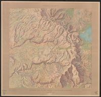
Beinecke Rare Book and Manuscript Library > Panoramic view of the Yosemite National Park, California.
Creator:
Published / Created:
1904
Call Number:
848 M215 1904
Container / Volume:
BRBL_00634
Image Count:
1
Resource Type:
Maps, Atlases & Globes
Description:
"Julius Bien & Co. Photo Lith. N.Y." in lower right margin., "Professional paper no. 45 PL. XI" in upper right margin., and Relief indicated by contours and notes.
Publisher:
Geological Survey,
Subject (Geographic):
McKinley, Mount, Region (Alaska)--Maps
Subject (Name):
Geological Survey (U.S.)
Found in:
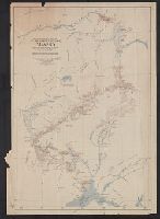
Beinecke Rare Book and Manuscript Library > Reconnaissance map of Mt. McKinley region, Alaska / Alfred H. Brooks, geologist in charge. Topography by D.L. Reaburn. Surveyed in 1902. Additional information compiled from surveys by U.S. Geo. Surveys and U.S. Army.
Creator:
Published / Created:
1919
Call Number:
841fcm 1919
Container / Volume:
BRBL_00597
Image Count:
1
Resource Type:
Maps, Atlases & Globes
Description:
"Lands designated by the Secretary of the Interior, under the provisions of the Enlarged Homestead Acts.", Prime meridians: Greenwich and Washington., and Relief shown by hachures.
Publisher:
Dept. of Interior,
Subject (Geographic):
New Mexico--Maps
Subject (Name):
Bauman, Wm. (William), Geological Survey (U.S.), and United States. Dept. of the Interior
Found in:
Beinecke Rare Book and Manuscript Library > State of New Mexico / compiled by A.F. Dinsmore ; traced and lettered by Wm. Bauman ; engraved and printed by the U.S. Geological Survey.
Branch:v1.61.8 ,Deployed:2024-06-20T11:14:46-04:00