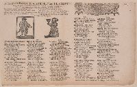
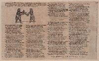
BEIN 2000 Folio 6 210: Mounted to 30 x 42 cm., In two parts, printed side by side., Publisher's names and date of publication from Wing., Verse - "It grieves my heart to tell the woe"., and With, on verso: Letter from a Christian family. [London]: Printed for W. Thackeray, J.M. and A.M., [1680]
Publisher:
Printed for A. M[ilbourn] W. O[nley] and T. Thackeray, in Duck-Lane,
Subject (Name):
Stewart, James,--Sir,--1635-1713--Poetry and Wharton, George,--Sir,--1617-1681--Poetry
Comfort to a contented minde and Looking-glass for a covetous miser
Description:
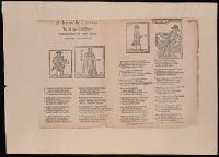
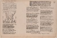
BEIN 2000 Folio 6 234: Mounted to 30 x 42 cm., Place and date of publication and publisher's names from Wing., and Verse - "Come listen kind neighbours with heart and good".
Publisher:
Printed for W[illiam]. Thackeray, T[homas]. Passinger and W[illiam]. VVhitwood,
Subject (Topic):
Ballads, English--England--Texts and Misers--Poetry--Early works to 1800
Anville, Jean Baptiste Bourguignon d', 1697-1782 Chapman, Thomas, fl. 1790-1803 Neele, Samuel John, 1758-1824, engraver Pauw, Cornelius, 1739-1799. Philosophical dissertations on the Egyptians and Chinese
Published / Created:
Jany. 1st, 1795.
Call Number:
1977 Folio 177
Image Count:
2
Resource Type:
Maps, Atlases & Globes
Description:
"Neele, sculpt.", Ms. note at head of title: De Pauw. Sheet measures 50.7 x 63.8 cm. No. 15 of 34 maps bound together., Prime meridians: Ferro., Relief shown pictorially., and Watermark.
Electorate of Brunswick-Luneburg with its dependencies
Description:
Imperfect: torn along fold, with some loss of text. Sheet measures 75.0 x 62.4 cm. No. 30 of 34 maps bound together., Inset map: Plan of the battle of Minden on the 1st of August 1759., Prime meridian: Ferro., and Relief shown pictorially.
Jefferson, Thomas, 1743-1826 Jefferson, Thomas, 1743-1826. Notes on the state of Virginia Neele, Samuel John, 1758-1824, engraver Stockdale, John, 1749?-1814
Published / Created:
1787
Call Number:
1977 Folio 177
Image Count:
2
Resource Type:
Maps, Atlases & Globes
Description:
"The country on the eastern side of the Alleganey Mountains, is taken from Fry and Jefferson's Map of Virginia and Scull's Map of Pennsylvania ... that on the western side of the Alleganey, is taken from Hutchins ... additions have been made, where they could be made on sure ground.", From the author's Notes on the State of Virginia. 1787., Prime meridian: Philadelphia., Relief shown pictorially and by hachures., Sheet measures 66.3 x 60.3 cm. No. 1 of 34 maps bound together., and Shows boundaries.