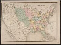
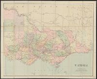
"41" printed in upper right margin., Borders are hand-colored., Imperfect: chipped along edges and torn along fold, with no loss of text., Includes New York State and adjacent areas., and Relief shown by shading.
Publisher:
Pubd. ... by J. Arrowsmith, 33 East St. Red Lion Square,
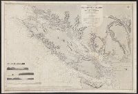
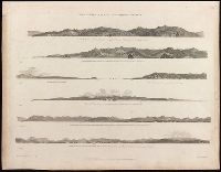
"Juan de Fuca Strait from Capt. Henry Kellett's survey of 1847. Shores of Washington Territory from the United States Coast Survey.", At head of title: North America, west coast., Includes 6 coastal views., and Relief shown by hachures and spot heights. Depths s
Publisher:
The Admiralty,
Subject (Geographic):
Vancouver Island (B.C.)--Maps
Subject (Name):
Arnold, Robert M.--Ownership, Davies & Powell, Mayne, R. C, Powell, E. J, and Richards, G. H. (George Henry)
Subject (Topic):
Coasts--British Columbia--Maps and Coasts--Washington (State)--Maps
Voyage of discovery to the North Pacific ocean, and round the world.
Image Count:
1
Resource Type:
Maps, Atlases & Globes
Description:
Cape Mendocino ... / J. Sykes, delt. -- Cape Orford ... / J. Sykes -- Cape Orford bear[in]g. S.S.E. 10 miles distant / J. Sykes -- Cape Gregory -- Point Grenville ... / J. Sykes -- Entrance to the Straits of Juan de Fuca ... / H. Humphrys, delt. -- A continuation of the above coast s[out]hward. from Cape Flattery, Mount Olympus ... / H. Humphrys. and Seven views on 1 sheet.
Publisher:
Published May 1st, 1798, by R. Edwards, New Bond Street, J. Edwards Pall Mall & G. Robinson, Paternoster Row,
Subject (Name):
Alexander, William (1767-1816), Edwards, James, 1756-1816, Edwards, Richard, Humphrys, Henry, -1799, and Pouncy, Benjamin Thomas, d.
Subject (Topic):
Coasts--Northwest Coast of North America--Pictorial works--Early works to 1800.