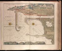
"Aen de nieuwen brugh met previlegi"., Backed with paper. Ms. no. "58" in upper right-hand corner. Sheet measures 53.7 x 62.3 cm. No. 53 of 87 maps bound together., Bar scale given in "Duytsche Myl"., Relief shown pictorially; depths shown by soundings., With north oriented towards the right., and With two inset maps at bottom: "Caap Cette N W ten N4" and "Caap Cette N W ten W 3."
Publisher:
By Gerard van Keulen,
Subject (Geographic):
Sète (France)--Maps--Early works to 1800.
Subject (Topic):
Nautical charts--France--Sète--Early works to 1800.
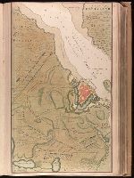
Backed with paper. Ms. no. "13" in upper right-hand corner. Sheet measures 53.6 x 35.5 cm. No. 13 of 87 maps bound together., Bar scale given in "Duytsche Mylen"., Relief shown pictorially; depths shown by soundings., Shows troop positions during siege of Stralsund during the Northern War, ca. 1715., and Title derived from place locations on map.
Publisher:
By Gerard van Keulen ...,
Subject (Geographic):
Rügen Island (Germany)--Maps--Early works to 1800. and Stralsund (Germany)--Maps--Early works to 1800.
Subject (Name):
Anse, Luggert van, fl. 1690-1716, engraver.
Subject (Topic):
Nautical charts--Baltic Sea--Early works to 1800. and Northern War, 1700-1721--Maps.
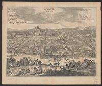
From Augustin Calmet's Byvoegzel tot het algemeen groot historisch, oordeelkundig, chronologisch, geografisch, en letterlyk naam- en woord-boek (1731). and Watermark.
Publisher:
[Samuel Luchtmans],
Subject (Geographic):
Antioch (Turkey)--Pictorial works--Early works to 1800.
Subject (Name):
Calmet, Augustin, 1672-1757. Byvoegzel tot het algemeen groot historisch, oordeelkundig, chronologisch, geografisch, en letterlyk naam- en woord-boek. and Luchtmans, Samuel, 1685-1757
Bird's-eye view., Dutch and English., From Ogilby's Africa, being an accurate description of the regions of Egypt, Barbary, Lybia and Billedulgerid. 1670., Has watermarks., Includes ill. and indexes of points of interest., and Relief shown pictorially.
Publisher:
Printed by T. Johnson for the author,
Subject (Geographic):
Loango (Congo)--Aerial views--Early works to 1800
Subject (Name):
Ogilby, John, 1600-1676. Africa, being an accurate description of the regions of Egypt, Barbary, Lybia and Billedulgerid
Affbeeldinghe der custen des landts genaempt terra do Natal, item van alle de custen van Coffala, Mozambique, Melinde and Typus orarum maritimarum Guineae, Manicongo, & Angôlae ultra promontorium Bonae Spei.
Description:
Appears in the author's Itinerario, voyage ofte schipvaert van Jan Huygen van Linschoten naer Oost ofte Portugaels Indien., Companion map to Typus orarum maritimarum Guineae, Manicongo, & Angôlae ultra promontorium Bonae Spei ..., and Includes decorative carto
Publisher:
Cornelis Claesz?,
Subject (Geographic):
Africa, Eastern--Maps--Early works to 1800
Subject (Name):
Claesz, Cornelis, approximately 1546-1609, Langren, Arnold Florent van, 1580-1644, and Linschoten, Jan Huygen van, 1563-1611. Itinerario, voyage ofte schipvaert van Jan Huygen van Linschoten naer Oost ofte Portugaels Indien
Subject (Topic):
Coasts--Africa, Eastern--Maps--Early works to 1800
Affbeeldinghe der custen des landts genaempt terra do Natal, item van alle de custen van Coffala, Mozambique, Melinde and Typus orarum maritimarum Guineae, Manicongo, & Angôlae ultra promontorium Bonae Spei.
Description:
Appears in the author's Itinerario, voyage ofte schipvaert van Jan Huyge, Companion map to Typus orarum maritimarum Guineae, Manicongo, & Angôlae ultra promontorium Bonae Spei ..., Has watermark., and Includes decorative cartouche and compass rose and col. ill.
Publisher:
Cornelis Claesz?,
Subject (Geographic):
Africa, Eastern--Maps--Early works to 1800
Subject (Name):
Claesz, Cornelis, approximately 1546-1609, Langren, Arnold Florent van, 1580-1644, and Linschoten, Jan Huygen van, 1563-1611. Itinerario, voyage ofte schipvaert van Jan Huygen van Linschoten naer Oost ofte Portugaels Indien
Subject (Topic):
Coasts--Africa, Eastern--Maps--Early works to 1800
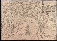
Afbeeldinge der custen van Abex, der engte van Mecha, anders ghenaempt de Roode Zee, Item de custen van Arabien, Ormus, Persen tot Sinde toe and Deliniantur in hac tabula, Orae maritimae Abexiae, freti Mecani ; al. Maris Rubri ; Arabiae, Ormi, Persiae, suprà Sindam usque Fluminis Indi, Cambaiae Indiae et Malabaris, Insulae Ceylon, Choromandeliae, et Orixae, fluvii Gangis, et Regni Bengalae, situs item Sinuum, Insularum
Description:
Backed with paper., From the author's Itinerario, voyage ofte schipvaert van Jan Huygen van Linschoten naer Oost ofte Portugaels Indien., Includes decorative cartouche and compass rose., Relief shown pictorially., and Title in Latin and Dutch. Place names in Latin and Dutch.
Publisher:
[Cornelis Claesz?],
Subject (Geographic):
Africa, Eastern--Maps--Early works to 1800., India--Maps--Early works to 1800., and Iran--Maps--Early works to 1800.
Subject (Name):
Langren, Henricus F. ab (Henricus Florentius), approximately 1574-1648. and Linschoten, Jan Huygen van, 1563-1611. Itinerario, voyage ofte schipvaert van Jan. Huygen van Linschoten naer Oost ofte Portugaels Indien.