Skip to search
Skip to main content
Skip to first result
Search
You Searched For
Date
Unknown
Resource Type
Maps, Atlases & Globes
Creator
Keulen, Gerard van
Date Created
[Missing]
New Search
Search Results
Creator:
Call Number:
1973 Folio 103
Collection Title:
De Nieuwe groote lichtende zee-fakkel ...
Image Count:
1
Resource Type:
Maps, Atlases & Globes
Subject (Topic):
Atlases., Islands, and Nautical charts.
Collection Created:
tAmsterdam, Johannes van Keulen, 1753-81
Found in:
Beinecke Rare Book and Manuscript Library > De Oostin-dische zee / Het Eyland Mayota
Creator:
Call Number:
1973 Folio 103
Collection Title:
De Nieuwe groote lichtende zee-fakkel ...
Image Count:
1
Resource Type:
Maps, Atlases & Globes
Subject (Geographic):
Madagascar
Subject (Topic):
Atlases., Islands, and Nautical charts.
Collection Created:
tAmsterdam, Johannes van Keulen, 1753-81
Found in:
Beinecke Rare Book and Manuscript Library > Des rivier legt op de Hoogte von 18 Graaden Zuyder Breedte aan het Land van de Megosie ter Kuste van Quama / Noord kust van't eyland ...
Creator:
Call Number:
1973 Folio 103
Collection Title:
De Nieuwe groote lichtende zee-fakkel ...
Image Count:
1
Resource Type:
Maps, Atlases & Globes
Subject (Geographic):
Madagascar
Subject (Topic):
Atlases and Nautical charts.
Collection Created:
tAmsterdam, Johannes van Keulen, 1753-81
Found in:
Beinecke Rare Book and Manuscript Library > Madagascar
Creator:
Call Number:
303cea 1680
Container / Volume:
BRBL_00033
Image Count:
1
Resource Type:
Maps, Atlases & Globes
Alternative Title:
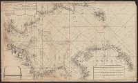
New sea map of the whole North Sea and Nouvelle carte marine generale de la Mer du Nord
Description:
Appeared in Joannes van Keulen's De Nieuwe groote, Backed with paper. Sheets measure 61.0 x 52.2 cm or smaller., Includes five bar scales., Relief shown pictorially; depth shown by soundings., and Scale estimated by measurement of degree of latitude.
Subject (Geographic):
North Sea--Maps--Early works to 1800
Subject (Topic):
Nautical charts--North Sea--Early works to 1800
Found in:
Beinecke Rare Book and Manuscript Library > Nieuwe groote paskaart van de geheele Noord-Zee : vertoonende in sig alle de rivieren, havens, baye, dieptens daar in geleegen = The new sea map of the whole North Sea : sheuwing all the rivers,, harbours, bays et havens et dephts, et showles = Nouvelle c
Branch:v1.61.6 ,Deployed:2024-06-12T09:55:19-04:00