Gouwen, Gilliam van der, engraver Visscher, Nicolaes, 1649-1702, cartographer
Call Number:
36 1706
Container / Volume:
BRBL_00117
Image Count:
1
Resource Type:
Maps, Atlases & Globes
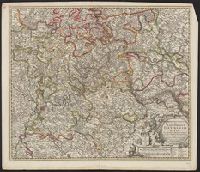
Description:
Borders are hand colored; larger cites are illustrated and colored red., Decorative title cartouche., Relief shown pictorially., Shows towns, rivers, and cities., and With reference grid.
Subject (Geographic):
Rhineland-Palatinate (Germany)--Maps--Early works to 1800
Mappa Aestivarvm insularum, alias Barmvdas dictarum
Description:
Below map, list of proprietors in 12 columns flanked by coats-of-arms., Borders are hand colored., and Not hand colored. With watermark. Sheet measures 46 x 55 cm.