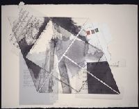
Drawing in red chalk on hand-ruled paper by an unidentified artist, of the decorative cartouche for John Mitchell's Map of the British and French dominions in North America. Represented in the drawing are two Native American figures in the lower right corner, a colonial port scene in the lower left corner, and cherubs holding a British crest and flag at the top. Corn and palm trees form the side borders
Description:
John Mitchell (1711-1768), was a British botanist, physician, and cartographer. He created A Map of the British and French dominions in North America (London: Andrew Millar, 1755), also known as the Mitchell Map, later used in negotiating the 1783 Treaty of Paris., No linguistic content., Title devised by cataloger., and Place and date of creation supplied by cataloger.
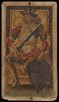
BEIN PLAYING CARDS GEN 966: Imperfect: 16 cards only. From the Cary Collection of Playing Cards., Title devised by cataloger., Latin/Italo-Portuguese suit system., and Composition of deck unknown.
Section titled "S. Maria Gloriosa dei Frari," score, autograph manuscript, and drafts for this and other sections, short score, autograph manuscript, some dated 1947 August-September
Alternative Title:
Chiese di Venezia
Description:
Ermanno Wolf-Ferrari, Italian composer., Chiese di Venezia, for orchestra, composed circa 1948, incomplete., Staff notation., Title devised by cataloger., and Date of creation supplied by cataloger.
Title supplied by cataloger., An optical box (or boîte d'optique) for viewing peepshows; accompanied by 10 peepshows displaying a variety of scenes., Peepshows possibly engraved and printed by Martin Engelbrecht of Augsburg., To use the box, the viewer looked through the magnifying lens and saw, reflected in a mirror placed at a 45-degree angle, a three-dimensional scene formed from a series of six layered images., Each of the 10 accompanying peepshow sets contains six views; all of the views are printed on stiff paper, are hand colored and have been cut out except for the sixth which forms the background and has the number 6 printed at the bottom. In some cases view 5 also has the number printed at the bottom., Each peepshow is housed in an individual packet of paper with a manuscript title in Dutch; the packets have been hand numbered nos. 1-9 and no. 11 and, on the verso of each view, the set number and the view number have been added in ms., and Within the background view of set no. 6, the letter H is printed in the lower left corner.
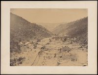
A salted paper photographic print that documents placer gold mining operations on river bars on the American River, Middle Fork, between Placer County and Eldorado County, California in February 1858. From an elevated position, the view shows mining operations on a wide riverbed running through hills of chaparral. The photograph depicts a viaduct, wooden structures, and water diversion structures, such as sluices, sluice gates, and waterwheels. The image includes mining camps and operations on the Kennebec, Wildcat, Willow, and Hoosier bars
Description:
Charles L. Weed (1824-1903), also known as Charles Leander Weed, was an American photographer and engraver. and Title devised by cataloger.
Subject (Geographic):
California, American River Region, American River, Middle Fork, American River Valley, American River, Middle Fork (Calif.), El Dorado County (Calif.), and Placer County (Calif.)
Subject (Name):
Weed, Charles L.
Subject (Topic):
Chaparral, Diversion structures (Hydraulic engineering), Gold mines and mining, Mines and mineral resources, Mining districts, Placer mining, and Water-wheels