Appears in Blaeu's Atlas major., Bar scale given in milliaria Germanica communia., Ferro meridian., Includes illustration of animals and ornamental cartouche., No. 60 of 69 maps bound together in composite atlas., Relief shown pictorially., and Scale [ca. 1:12 000 000].
Publisher:
[Joan Blaeu]
Subject (Geographic):
Africa, Central --Maps --Early works to 1800 and Africa, Eastern --Maps --Early works to 1800
Africa distinguished into its principall parts viz. Barbary, Biledulgerid, Egypt, Zaara or the Desart, the Country of the Negroes, Guinea, Nubia, Abissinea, Zanguebar, Congo, Monomotapa, Caffrares, the Islands of the Canaries, Cape Verd, St. Thomas, Madagascar or St. Lawrence in which are observed the empires, monarchies, kingdomes, states and peoples, which at present inhabite Africa
Description:
Ferro meridian., No. 56 of 69 maps bound together in composite atlas., Relief shown pictorially., Scale [ca 1:34 000 000]., and To the most serene and most sacred majesty of Charles II, by the grace of God, king of Great Brittain, France, and Ireland, this map of Africa is humbly dedicated and presented by your majesties loyal subject and servant, William Berry.
Publisher:
Sold by William Berry at the sign of the globe between Charing Cross and White-Hall
Also appeared in Kitchin's General atlas describing the whole universe. London : Printed for Robert Sayer, [1780]., By S. Boulton ; and also a summary description relative to the trade and natural produce, manners and customs of the African continent and islands., Insets: A particular chart of the Gold Cost. -- Azores or Western Islands., No. 35 of 43 maps bound together in composite atlas., Scale [ca. 1:8,500,000]., Sheets pasted together to create 1 map on 2 sheets., and With descriptive text.
Publisher:
Printed for Robert Sayer
Subject (Geographic):
Africa --Maps --Early works to 1800 and Ghana --Maps --Early works to 1800
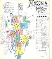
Sanborn fire insurance maps are a rich source of historic data on the urban built environment of North America during the 19th and early 20th centuries. The atlases were created for the purpose of underwriting fire insurance policies, which depended upon accurate and frequently-updated information about construction materials, municipal and transportation infrastructure, industrial and commercial landuse and more. The Yale University Library Map Department scanned its holdings of Sanborn fire insurance maps (consisting primarily of Connecticut towns) in order to make the maps more accessible.
Alternative Title:
Ansonia, Connecticut and Dec. 1890, Ansonia, Conn.
Description:
"13 sheets (4176).", Contains information on population, water facilities, and fire department., Includes index of streets and specials., Partial cadastral map., and SMLMAPL 766 An81 1890: Sheets disbound. "Triplicate" stamp on all sheets. Library of Congress copyright stamp on title sheet.
Subject (Geographic):
Ansonia (Conn.)--Maps
Subject (Name):
Library of Congress Stamp
Subject (Topic):
Fire risk assessment--Connecticut--Ansonia--Maps and Real property--Connecticut--Ansonia--Maps
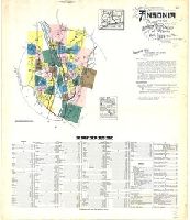
Sanborn fire insurance maps are a rich source of historic data on the urban built environment of North America during the 19th and early 20th centuries. The atlases were created for the purpose of underwriting fire insurance policies, which depended upon accurate and frequently-updated information about construction materials, municipal and transportation infrastructure, industrial and commercial landuse and more. The Yale University Library Map Department scanned its holdings of Sanborn fire insurance maps (consisting primarily of Connecticut towns) in order to make the maps more accessible.
Alternative Title:
Ansonia, Connecticut and Mar. 1924, Ansonia, Conn.
Description:
"39 sheets (1516).", Contains information on population, prevailing winds, water facilities, and fire department., Includes index of streets and specials., Partial cadastral map., and SMLMAPL 766 An81 1924: Sheets disbound.
Subject (Geographic):
Ansonia (Conn.)--Maps
Subject (Topic):
Fire risk assessment--Connecticut--Ansonia--Maps and Real property--Connecticut--Ansonia--Maps
Anville, Jean Baptiste Bourguignon d', 1697-1782 Cook, James, 1728-1779 Kitchin, Thomas, d. 1784, creator Sayer, Robert, 1725-1794
Published / Created:
1787 January 6
Call Number:
1982 Folio 10
Image Count:
2
Description:
Also appeared in Kitchin's General atlas describing the whole universe. London : Printed for Robert Sayer, [1780]., No. 29 of 43 maps bound together in composite atlas., Relief shown pictorially., Scale [ca. 1:11,100,000]., Sheets mounted together to form 2 sheets., Shows boundaries, rivers, settlements, islands; includes descriptive notes., and Title cartouche depicts local produce, a palm tree and a camel.
At head of map: Asia distinguished into its principall parts viz. Turky in Asia, Arabia, Persia, India, China, Tartaria, the islands of Japan, of the Philippines, of the Moluckes, of the Sundaes, of Ceylan, and of the Maldivies, where are set down the empires, monarchies, kingdoms, and states which are found there at present., Dedication in cartouche: To the most serene and most sacred majesty of Charles II by the grace of God, King of Great Brittain, France and Ireland. This map of Asia is humbly dedicated, and presented by your majesties loyal subject, and servant William Berry., Map of Asia from Saudi Arabia, Russia, India, China, Japan to Southeast Asia. Relief shown pictorially., No. 49 of 69 maps bound together in composite atlas., and Scale [ca. 1:12 165 120].
Publisher:
Sold by William Berry at the signe of the Globe between Charing-Cross and White-Hall
Subject (Geographic):
Asia --Maps --Early works to 1800, Asia, Central --Maps --Early works to 1800, South Asia --Maps --Early works to 1800, and Southeast Asia --Maps --Early works to 1800